Sunday, July 26, 2009
Preview - Table of Contents
Saturday, July 25, 2009
Welcome and Introduction
Illustrations from "Walden," by Henry David Thoreau, and "Lake Wobegon Days" by Garrison Keillor, two books and two places with much in common.
Long before our departure, however, I shifted the purpose toward environmental education and broadened the trip's scope to be a personal investigation of all freshwater resources -- lakes, ponds, rivers, streams, springs, precipitation, soil moisture, and clouds -- we would encounter along the way. So, instead of spending our off-road time speaking to independent bookstores and media outlets, we spent it surveying the attitudes of ordinary people on the subject of fresh water.
Ossipe River near Freedom, New Hampshire.
Everywhere we went -- streets, parks, motels, restaurants, gas stations, museums, libraries, stores, offices, roadsides, bait shops, taverns, kiosks, and visitor centers -- we asked the same double-edge question: “What to you like best about fresh water? And what is your main concern?" Some of the answers we got were astonishing, for example the breakfast host in Aberdeen, South Dakota who didn’t know what freshwater was. Most were surprising because the "water question" was so open-ended. Most importantly, the answers we got were regionally specific because each water sub-culture has its own delights and issues.
Bob Job, an employee of Linton, North Dakota, pondering the upcoming vote about whether to join the regional water district or to continue relying on municipal wells.
For example, on June 28, we attended a rain-soaked meeting of the Bear Pond Improvement Association in North Turner, Maine. There we heard the good news that the clarity of the lake was improving and the bad news that more than half of the loon deaths statewide are due to lead poisoning. Nearly three weeks later, we were in visiting the sun-baked badlands of Theodore Roosevelt National Park in Medora, North Dakota. There, a kayaker was reflecting on the beautifully braided Little Missouri River before wincing about a defiant rancher who strung an electrified wire across a publicly managed stream, nearly garroting one of their party.
Little Missouri River at Medora, North Dakota. Note the red gravel bars.
To such water stories by local residents, I added my own observations as seen through the bug-spattered windshield of our dented station wagon. For example, in Hackensack, Minnesota (alleged to be the home of Paul Bunyan’s domineering wife Lucette), we saw a team of eight reindeer created as folk art from rusty home heating-oil tanks. Some had probably leaked into local aquifers before being discarded. I also added stories excerpted from local newspapers you probably never heard of. For example, in Williston, North Dakota, the U.S. Air Force had been strafing the city with insecticide on behalf of a municipal bureaucracy called the “Vector Control,” which was coping with a mosquito problem exacerbated by the U.S. Army Corps of Engineers.
Collectively, the personal anecdotes we were told, the observations we made, and the daily newspapers we read, constitute a time capsule of water stories from the summer of 2009. But the climate is changing, the population is growing, energy development is threatening, recreational activities are shifting, kids are paying less attention, and concerns about public health are rising. How will the water stories change in the coming half century?
Our geographic focus was the glaciated fringe of the former Laurentide Ice Sheet, which covered the northern and north-central United States (including southern Ontario) until about 15,000 years ago. Extending from the crystal clear ponds in New England to the potholes along the Lewis and Clark Trail in the High Plains, this enormous glacier was largely responsible for creating the lakes, watersheds and aquifers found today, including the inland seas called the Great Lakes.
Mural painted on an oil tank at Port Stanley, Ontario (Lake Erie) suggests an oceanic affinity to what is obviously a freshwater lake.
We stuck to the back roads as much as possible, beginning with the rain-soaked, winding pavements of Maine’s lake district and ending with the dry-baked, ramrod-straight gravel roads of Sheridan County, Montana. Our journey took us through the highlands of New Hampshire; the 18th century villages of Massachusetts, Rhode Island, and Connecticut; the rolling Berkshires in western Massachusetts and the Green Mountains of Vermont; the Lake Champlain Lowlands and the Adirondacks of upstate New York; the Saint Lawrence River and the northern shores of Lakes Ontario and Erie; Michigan’s mitten and its and Upper Peninsula; across Wisconsin’s Ice Age Trail; here and there in Minnesota; and west through the prairie potholes of the twin Dakotas. Throughout it all, we kept our feet on the ground and the rubber on the road, riding the thin interface between earth and sky, the place where hydrology happens.
North Shore of Lake Michigan west of Saint Ignace, Michigan.
Intense traffic happened only twice: northwest of Boston near Minuteman National Park, and on “The 401” during rush hour through Toronto. On two occasions, we were completely alone: nearly stuck on a washed-out logging trail in central New Hampshire, and on Route 216 in eastern Montana where we cruised along on a midsummer Friday afternoon without seeing a single stop sign or human being for an hour.
Montana Route 216 between Wibaux and Sydney was the lonliest stretch of the trip.
With Kristine driving, I was free to drink in the scenery and soak up what people were saying. And being a very early riser by habit, I had five hours before checkout time each morning to distill the previous day's experiences and pour them into a daily posting. After reaching the outermost point of the trip, we rode the westerly prairie winds back to Bemidji, Minnesota (getting nearly 34 miles per gallon in a loaded Volvo station wagon). There, I hid for a week in my parents empty house to edit the results into a narrative stream that I hope will be a novel contribution to the environmental education literature.
Walden to Wobegon: A Freshwater Journey from Maine to Montana, is book-length web-journal, written in the anecdotal style of John Steinbeck’s Travels with Charley and William Least Heat Moon’s Blue Highways, but with a tight focus on freshwater. It combines the intensity and quirkiness of a daily diary with the measured pace and uniform style of an edited manuscript. Following the "Preview-Table of Contents," and this Introduction are twenty chapters, one for each day of the road trip. The final chapter is a retrospective written from the perspective of the journey home.
Perhaps you're a fan of crossword puzzles. If so, then clinker, couteau, coulee, aquifer, aquamarine, artesian, pothole, bentonite badland, anhydrous, ammonia, flocculation, fluoride, LUST, limnions, kettles, and catchment are just a few of the words I would have used to design a puzzle from the trip. If you're a fan of literature, then you might enjoy the story of Bob Job from Linton, North Dakota. Were he Shakespeare, he might have written: "To drink or not to drink (water from the Missouri River)....That is the question." If you like mysteries, then you might wonder why there's no pipeline or water truck traffic between Poland Spring and the corporation's bottling plant.
For factual and analytical information about water resources, there are plenty of data-rich, highly vetted, and politically correct documents available from government agencies and scientific organizations. But if those formats are not your cup of tea, I hope you will read, enjoy, and learn from this quirky web-journal.
Friday, July 17, 2009
Day 20 - The Final Distance
Medora was a lovely place to lake up. Bright sun. Crisp Air. Hardly a trace of humidity.
Cowboy Town
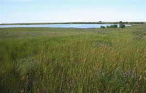
Bluffs behind Medora, North Dakota, were cut by the Little Missouri River.
At one time, the high plains were continuous from the Rocky Mountain Front near Denver to the Mississippi River. Beneath them are the clay, silt, and sand of coalesced deltas and wide alluvial plains deposited by large lazy rivers carrying sediment eastward a wet, semi-tropical climate. Today's rugged topographic relief and the "badlands" exposure of ancient strata are due entirely to localized down-cutting by modern streams.
At the Visitor Center of the Theodore Roosevelt National Park, we took tour of the Maltese Cross Ranch house guided by Mary Ellen Ergle.
Maltese Cross Ranch House, Theodore Roosevelt National Park, Medora, North Dakota.
If I understood correctly, this cabin-sized ranch house was built for Teddy Roosevelt long before he became president. He and the cowboys he employed on his ranch lived in it together. Originally located on the site of the Maltese Ranch, it has been moved for exhibitition many times, finally ending up at the park visitor’s center.
Desiccated timber at the Maltese Cross Ranch Cabin, Theodore Roosevelt National Park, Medora, North Dakota.
Two related themes from the day are shown in the photo above. First is the crispness of the shadows created by intense sunlight. Such sunlight can only occur when the air is extremely clear, as it is here because there is little moisture in the air. With such little moisture, wood above the soil surface preserves very well. And when accompanied by a steady breeze, the rate of evaporation is very high, causing desiccation. Water, rather than nutrient, sets the limit on life in this place.
Later, Mary Ellen reflected on how beautiful the water was in all of its splendid turbidity, with pastel earth tones ranging from slightly off white to reddish brown. Her main concern was that energy development was raising pressures to build another bridge across the Little Missouri River, which she believes would compromise the beauty of the land she has learned to love. They would truck it on what is now a silent place.
Another staff person, Lilian Crook described a kayak trip that offered unexpected pleasure of floating by a family of baby beavers swimming with one of their parents. Here concern was with low-water crossings, which were being filled to cross with vehicles, changing the courses of streams.
Material on exhibit at the Medora Historical Museum, Medora, North Dakota.
During western settlement, the materials of everyday life came almost entirely from factories in the eastern and Midwestern United States. In an earlier era, material for New England and Virginia colonies came almost entirely from factories in the Old World. As much as westerner's pride themselves on their independence, they were, and remain, dependent on eastern commodities and services.
The Custer section at the Western Edge Bookstore in Medora, North Dakota.
Never have I seen an entire wall of books about General George Armstrong Custer.
American in general and this town in particular have a love-hate relationship with General Longhair, whose final moments captured many emotionally-rousing themes associated with the human condition: tragedy, revenge, war, heroism, misjudgment, race, arrogance, Manifest Destiny, Native Americans, cultural extinction. In my quick scan of the section, shelf, I found only one book dedicated to the Indian point of view.
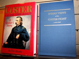
Adjacent books from the Custer section of Western Edge Bookstore in Medora, North Dakota.
The plain cover on the book about Indian views suggests that it’s the content of history that matters, not the marketing.
Cotton was flying everywhere in Medora. It carries the seeds of the cottonwood tree on the wind; hopefully to a spot wet enough for germination.
Cottonwood tree, downtown Medora, North Dakota.
With such a steady breeze from the west, I wondered how such a tree could ever spread upwind in that direction. For the rest of the day we saw cottonwoods lining the bottom of every watercourse, from small creeks to the banks of the Yellowstone River.
The strata around Medora are rich in bentonite, a clay produced as a byproduct of the weathering of volcanic ash. One of the most fascinating things about bentonite is that it actually takes water into the mineral structure, expanding in the process, and producing a water-tight seal. It’s impervious to infiltration that is used to line the bottom of ponds and the casings of wells. So, when it rains around here, the water cannot infiltrate. Rather the rain runs off, usually in torrents, which is why a city like Medora needs to pay special attention to its surface drainage.
Cement drain in downtown Medora, North Dakota.
Red Clinker
Medora was so fascinating, that we left much later than we had planned to. Despite our urgency, we didn't drive more than a hundred yards before finding one of the most interesting water stories of the trip.
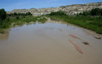
Little Missouri River, looking northeast from the bridge at Medora, North Dakota.
Taking this photo made me realize how interconnected the water system is on earth, in time as well as in space. Here, the river is muddy because it has incorporated and suspended river mud from an era when mammals were just beginning to dominate North America (Paleocene). Also in the river are gravel bars composed of an unusually red, quite jagged gravel.
That’s clinker, otherwise known as porcelanite. Essentially, it is natural “redware,” the name given to primitive pottery of colonial America during the 16th and 17th century. To manufacture that pottery, muddy clay was shaped on a potter’s wheel, then fired and glazed. Here, on the high plains drained by the Little Missouri, the muddy clay was fired by seams of lignite coal burning underground for millennia. They had formed tens of million years ago as peat deposited in freshwater swamps. After deep burial and exposure, the peat-turned-into-coal was set on fire by lightning strikes, and then burned for centuries or more.
Strata exposed in a highway road cut east of Beach, North Dakota, shows a bed of red clinker (burned coal) above black coal strata that are not burned.
The heat from the burning coal “fired” the adjacent muddy clay in to strong, but brittle rock. It is easily fractured, but will not fall apart back into mud.
Close-up of crushed clinker used for road-bed materials above bentonite soils on Montana Route 216 about five miles south of Sydney.
This natural red ware is the only source of gravel around here and is responsible for the unusual beauty of the river gravel bars. For human use, the clinker is crushed for gravel roads and substrate for pavements.
Red dust from gravel roads on back of Subaru Outback in Medora, North Dakota.
Hence the connection between the black coal in the outcrops and the red dust on the back of the Subaru Outback we saw parked on the street.
Borderlands
Interstate 94 west of Medora had light traffic. Only one car passed us when we stopped to photograph this water tower during mid-afternoon on a beautiful day.
Water tower in Beach, North Dakota, just east of the Montana line.
Beach? The nearest ocean beach is easily more than 1500 miles away. Some day, I’ll have the time to find out why this town was named.
Just over the border was the Montana Welcome Center at Wibaux. There we met Darlene Brown, who works for the local chamber of Commerce. She was completely surprised when I told her I was heading up toward Plentywood, far off the beaten track of tourists. Her main concern was that the water is so polluted with nitrates that it could “kill a baby.” This was from agricultural runoff and infiltration. Their family gets water from the well on their ranch. They don’t spray, except just once when the grasshoppers got too bad.
Beyond that was the town of Wibaux, itself, named for a cattle entrepreneur from France, On the way into town, I got my first exposure to culvert art, created by a local resident named Joe Burnam.
Bucking bronco art made from old culverts, Wibaux, Montana.
The library was our most interesting spot. Inside was a very senior librarian, a middle-aged librarian, and three teenagers working at the internet.
Main Street of Wibaux, Montana, just west of the Montana line.
Their Montana Room, which held books on the state, was formerly a walk-in small room-sized bank safe. The building had been built as a bank to keep all the money ranching produced. Later, it was the jail. Now, it houses precious books.
A senior in high school, Jackie Quinn relayed a story about almost drowning in the Yellowstone River near Billings to save her dog, which couldn’t swim. That was her response to a concern about freshwater, you can die in it. What she likes most about fresh water was that you can get it quite cheap at the Coke plant.
Astonished, I inquired further because I wanted to make sure I got the story right. Indeed, there is a Coca Cola bottling plant nearby. To meet manufacturing specifications, they have to filter and purify the water of its deep-down chemistry that is very soft, rich in sulfur and sodium. They go there with five gallon jugs, which they fill for approximately a dollar a piece. I wondered how different this Coke water was to the city water sold by the Water Depot in Woodstock for nearly four times the price.
Jackie wanted to know the blog address. When she found it, I noted her stile, to cruise through the photos until she got a photo that interested her, read the caption, then move on. I fear that much of this text will get unread as well.
A Lonely Stretch
From Wibaux, we drove north on Route 216, a distance of 54 miles, encountering no traffic either direction for the first fifty miles.
Route 216 midway between Wibaux and Sydney, Montana.
The central 12 miles were made of gravel, in this case of crushed clinker, a.k.a. porcelanite. I suspect that this material need not be mined at all, but could simply be dug directly from gravel bars in small rivers.
To the east and west, the road moved mostly through subdued badlands, with outcroppings being both rare and distant. Fences ran continuously along the way, with distant cattle visible on the hills. We encountered no human being working outside, despite the fact that we went by several clusters of ranch buildings in the last third of the way. En route, I wondered when the last person came through here in a Volvo with Connecticut plates.
The availability of water seemed to be the limit to ranching in this vicinity. One excavated stock pond we drove by in the distance was completely dry. From its white color and cracked appearance, we guessed it to be combination of bentonite clay and salt.
Dried up stock pond on the highlands on the road between Wibaux and Sydney, Montana.
More commonly, the beds of local streams would be excavated, with the dredging spoils being used to build a dam on the downstream side.
Excavated and dammed stream for livestock watering on Route 216 approximately a dozen miles south of Sydney, Montana.
The encrustations along the pond edge are a sure sign of excessive evaporation.
Approaching Sydney, we began to notice that oil wells were quite common.
Oil well borders the road between Wibaux and Sydney, Montana. Its gravel pad was composed of crushed clinker.
We saw dozens such wells within the next hundred miles.
Between the Rivers
Just south of Sydney, we crossed the floodplain of the Yellowstone River, which was covered with spray irrigation devices.
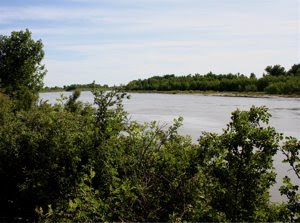
Yellowstone River at the bridge to Sydney, looking upstream to the south.
The river was turbid, but with a grayer color more suggestive of glacially ground up mid than with the rusted clays of badlands country. The edge of the river contained black chert and volcanic rock with free-floating crystals, exotic stones we had not seen since leaving the Canadian shield of northern Michigan. These were from ancient rocks in the distant Rocky Mountains, seemingly a world away.
The river also contained what most Midwesterners would call exotic fish, especially sauger.
Sign beneath bridge crossing of the Yellowstone River at Culberton, Montana, asking recreational fishermen to help with fish research.
At this point, the river flows in a fairly straight channel, beginning to meander near the North Dakota border before joining the Missouri at Buford, named for the historic Fort Buford. Between Buford and Williston the river flows about 40 miles to reach the western tip of Lake Sakakawea, which is impounded by the Garrison Dam more than a hundred miles to the east.
From the map, the Yellowstone flows more strongly than the Missouri. This prompts me to think not only of the Missouri River, but also of the headwaters question regarding the great Mississippi System. Why is the link between Buford, North Dakota, and Saint Louis, Missouri, not named the Yellowstone River? Why is the head of the Mississippi River considered to be more important than the head of the Missouri system, which is really the head of the Yellowstone system?
Sydney runs on cattle and oil. Driving through downtown, we couldn’t help but notice two culturally significant signs. The first was the “Lucky Buckle,” which looked like a clothing store from the street, probably selling western wear. A block down was the largest local watering hole (western-speak for drinking establishment): the “Cattle-ac Saloon.” It doesn’t get any better than that, a place that embodies America’s love of the automobile and its beef cattle in one word.
Cattle-ac Saloon in Sydney, Montana.
The same sun that makes such bright colors and stark shadows creates in human beings a powerful thirst and a desire for shade.
Our destination for this leg of the trip was Culbertson, Montana, which lies on the north side of the Missouri River. Was it an accident that both Sydney and Culbertson lay on the north side of the river?
Approximately four miles south of town, and on the east side of the road we spied an enormous boulder of hard rock, a banded gneiss with a vein of granite running right through it. Without question, this boulder had come from the Canadian shield, far to the northeast, perhaps from as far away as Keewatin, on the west side of Hudson Bay. We had crossed the glacial limit. I had suspected this earlier, having seen rounded, light-colored spots in the distance that I interpreted as ancient sun-bleached boulders, but which could have been the mounds of dirt above badger or prairie dog holes. The gneiss boulder weighed nearly a ton and was diagnostic of long-distance transport by ice.
Our purpose in leaving the glacial limit and re-entering it here was to see if the water issues of the glaciated landscape were different, which they were. South of the limit, the land was nearly overwhelmingly given over to ranching, principally for beef cattle, dominantly Angus and Hereford breeds. I don’t recall seeing a single dairy cow or any corn, except in a few protected hollows, or for that matter, many cultivated fields at all.
Gradually, the number of boulders picked up, to the point where we began seeing piles in cultivated fields. The brown layer above the rock outcrop thickened to the point where it could be confirmed as till, rather than the subsoil. Deposition of this substance, rather than erosion of soft strata became responsible for the undulating character of the terrain, something we hadn’t seen since near Mandan back to the east. Subdued buttes and sections of badlands were still present, but only on the high points, remnants too large to be sheared and smeared by the passing ice.
As we neared the Missouri River, we could see the gallery forest of cottonwoods along the meandering stream. The fields were rich on the alluvial plain, being watered with spray irrigation. In the distance, we could see a return to the Tertiary strata the glacier had covered to the slough. This return was due to erosion by the Missouri River, which carried torrents of glacial meltwater as an ice marginal stream.
Missouri River looking downstream to the east at Culbertson, Montana.
Beneath the Culbertson Bridge was an old, beaten-up U.S. Geological Survey Gauging Station.
Staff gauge for measuring water height at the Missouri River Bridge at Culbertson, Montana.
A staff, mounted on mangled sheet piling, was marked off in feet and tenths of feet to determine the height of the river, its stage. I found it curious that it was rust at the top and bottom, but not in the middle, where the pilings were white. This, I suspected, was the range in height at which swift-flowing currents carrying silt, scoured off any rust that forms on a nearly seasonal basis. Most of the time, the river runs fairly low.
Modern U.S. Geological Survey Stream Gauge at the Culbertson Bridge, Montana.
With the old gauge, a public servant drives out to the bridge, heads down to the river, and visually reads the gauge, sometimes with binoculars. With the new gauge, there is no need for an employee. Sunlight powers photovoltaic cells, which generate electricity to power an automated electronic transducer that reads the stage of the river by measuring the hydrostatic pressure in a column of water. That information is then automatically logged onto a digital file at the station and sent via radio waves to some distant computer for archiving and analysis. The clean, high-tech gauge is a lonely gauge, as independent as a Mars Rover.
When I graduated from college in 1973, one of my buddies got a job with the U.S. Geological Survey driving around and collecting data from stream gauges. Young people who used to work their way up the career ladder no longer have that opportunity. The analysts sit inside in front of a computer, as I am doing now, rather than being outside.
When westerners think of rivers, their thoughts are usually drawn either to the extremes of flow, whether destructive floods or times when the river dries up. Between those limits, we tend to take flowing water for granted. Those USGS analysts may not even see the rivers much anymore.
To the Limit
Two miles north of Culbertson, Montana was a dramatic change in the terrain. All of a sudden, we were on an undulating plain rich with cultivated fields and dotted with boulder piles here and there. Verdant green wheat was the principal crop, with yellow-flowering canola fields common as well.
When we reached Homestead, it seemed to us that we were back in the upper Midwest-- rather than the west. The cultural icon of the rain elevator, water tower, small towns smothered in trees, and endless fields surrounding them. Soil, rather than climate or culture, set the boundary between rangeland and farmland.
Medicine Lake was rimmed by extensive marshlands and many birds. Medicine Lake is one of the more important wildlife refuges run by the U.S. Fish and Wildlife Service.
Medicine Lake, Montana. The presence of water makes it easy to see how flat the landscape really is.
My original plan was to head north to Plentywood, Montana for the night. Later, we decided we might not find a motel or library there with the functional Internet service we needed to make our final blog post. Instead, we decided to overnight in Williston, North Dakota, the only place within 130 miles with more than one motel, so we were told. To reach Williston before dark, we had to turn east at Reserve, Montana before heading back into North Dakota.
Reserve exhibited a skyline dominated by grain towers little different from Edgeley, North Dakota, which we had seen four days earlier.
The limit of our trip at the junction of Route 16 North and Route 258 East, in Reserve, Montana. The town is barely visible left of the sign.
If Reserve has a water story, it’s the absence of a water tower visible from a distance. It lies on the banks of Big Muddy Creek. Perhaps after the sediment settles out, they have a reliable supply.
Were it not for the rich farmlands all around us, one might call this country bleak. We drove west by the Eden Valley cemetery, which was very well kept, despite being miles from the nearest valley and without so much as a tree. If ever there was a nearby church, its now gone, perhaps burned to the ground. Another sign that could be misinterpreted as signifying bleakness was a completely intact, but thoroughly abandoned set of farm buildings Brush Lake Road north of Dagmar.
Abandoned cluster of farm buildings (including the base of a windmill) northeast of Dagmar, Montana. The buildings are completely surrounded by wheat.
The windmill is an icon of the upland prairie, a place where groundwater is often the only source of water. One of my earliest memories was climbing such a windmill tower to its top, despite explicit instructions to stay away and despite the threat of certain punishment. I must have been less than five years old. I remember the combination of excitement and fear, and of feeling my heart throb in my chest in the process. Of course, my mother would have had heart failure had she known what I was up to. Perhaps she will find out in reading the account of this road trip.
Dagmar, set a half-mile in from the county road in the middle of a section, was an anomaly. People still live there on its two or three streets, and tend the cluster of trees that protect them from the wind. Driving by at a distance of a half mile, we saw no water tower, no grain elevator, and no steeple. This puzzled us. Here was a huddled community if I ever saw one. Mechanized machinery has expanded the distance between farms. Homesteads, which began at 160 acres, were not abandoned, but incorporated into ever-enlarging farms.
Our final stop on the entire trip was to visit Brush Lake; the most easily reached small kettle lake within a cluster that stretches northwest to Dooley near the Canadian border, and eastward into nearby North Dakota.
Brush Lake in Sheridan County, Montana. State park is the cleared patch of beach visible on the opposite shoreline.
To the south lay additional kettles within a kettle moraine, these occupied by various waterfowl and rimmed by marshes.
Here was a beautiful lake, precious in its rarity, and crystal blue in its quality. But people were completely absent. At its south end was a decrepit park, blocked by a locked gate. The few wood-frame buildings present seemed abandoned. Some were falling down, others being enveloped by brushy trees. There were no parked automobiles. We didn’t see or hear a soul.
After a steep climb to the east side of the lake, our first steep slope in more than twenty miles, we turned north on gravel toward Highway 258. Along the way, we passed by the road to Brush Lake State Park, which was clearly marked with a sign similar to the one we had seen seven miles back before we left the main road for Dagmar, and eighteen miles back when we left the main road at Reserve.
I regret not driving the mile of gravel road to the shore to see if there was someone to interview. Earlier, we had decided that the park must have been closed, because we saw no cars and no activity there when we stopped across the lake, seeing nothing but a small swimming beach with no cars and no people visible
It was there, surrounded by fields of silently growing wheat and at that lonely junction between two gravel roads, that our road trip ended.
Thursday, July 16, 2009
Day 19 - Good Lands and Badlands
Bismarck Folk
At breakfast, I was taken aback by Vernie’s comment. She was the sixty-something host for the restaurant at breakfast.
When asked her about the highs and lows of freshwater she looked puzzled, then agitated. So, I decided to back up and start with a more fundamental question as bluntly as I could: “Do you know what freshwater is?” “No,” was her reply.
In Bismarck, a land far from the sea, water is simply water. Once she understood what I meant by "freshwater," she responded by asking, “What would we do without it?” On the down side, she had “No complaints.” This was the most uncomfortable interview from the trip, The only worse encounter I had was a young woman waiting for the restroom in a sandwich shop who thought I had ulterior motives and decided to ignore me.
Missouri River between Bismark and Mandan, North Dakota.
My next informant was Doug, a 50-something hot-dog chef working beneath a tent outside of Dan’s supermarket. They were offering the great American diet of a hot dog and a coke for only a dollar. “Ya know, we don’t want no pollution in the water. That’s my concern.” He was also from California, having moved back to Bismarck to take care of elderly parents. He didn’t like the water from California’s reservoirs.
He much preferred the local water because it “came out of the mountains,” and flowed down the Missouri River. I then responded that most the Missouri River is dammed up and replaced by muddy reservoirs and that I thought Bismarck’s water came from a reservoir behind Garrison Dam. “That’s a lake,” he said referring either to Lake Audubon or Lake Sacagawea. If he likes the water for its associations, then that’s just fine with me.
Cattle and Coal
Lewis and Clark worked their way against the current of the Missouri River in 1805. Today, a similar trip would be on slackwater, within reservoirs impounded by great dams. The Missouri is one of the most heavily altered bodies of water in the nation, thanks to the U.S. Army Corps of Engineers. Basically, this isn’t North Dakota water at all, but Montana and Wyoming water east of the Cordilleran divide. They just don’t want to let it go by without using it first.
It wasn't long before we decided to take a sixty-mile side trip, which turned out to be an 82 mile side trip heading toward Center on Route 25, to visit the place where Kristine's ancestors emigrated after leaving Denmark in the late 19th century.
Cut bank of Square Butte Creek near Harmon, North Dakota. Square Butte Creek enters the Missouri just a few miles north of Mandan.
Terrace in the valley of Square Butte Creek near Harmon, North Dakota.
Cattle near Sanger, North Dakota, which lies above the Missouri River about 20 miles north of Mandan. They ran away when I approached.
Excavated livestock watering pond near Sanger, North Dakota.
Consider these to be artificial potholes. Here, the main problems are the concentration of alkali salts.
Before the 1960s, this was ranching country, with little else to support the economy. Now, there are jobs provided by the Minekota utilities corporation, which burns strip-mined coal for electric power.
Lone Wolf Saloon in Center, North Dakota,
It had three customers by early afternoon on Friday, July 16. I show this photo of the saloon where the coal miners hang out in lieu of a photo of the distant plants, which were too far to photograph well.
The plumes of the emissions stack run continuously, day and night. We also saw plumes west of Sanger, North Dakota, where something similar is taking place about ten miles to the northeast. Coal mining is another indicator that we had left the Upper Midwest for the true west. The Upper Midwest is underlain by the wrong kinds of rocks, and the glacial cover is much thicker.
From the coal-fired power plants, power lines head off toward Bismarck-Mandan. That city is literally lit up by strip-mining. It’s bright city lights also come with the consequence of carbon pollution. Concern about greenhouse emissions doesn’t seem to be a problem around here, probably because jobs are at stake. Another important point, is that these folks are used to taking whatever is thrown at them by the weather, blizzards, thunderstorms, hail, floods, droughts, locusts, deep freezes. It’s the city folk who seem to care most.
A side note on the issue of global warming. At 3:01 PM on July 16, 2009, we watched a local resident get out of his massive white Chevy pickup truck and walk into the gas station. In addition to the requisite blue jeans, he was wearing a puffy down coat over a thick insulated gray sweatshirt. I doubt that he is that concerned about global warming.
Curiously, there was a wind farm of several dozen turbines located between the two coal mining operations, probably within sight of both.
Immigration
Our side trip to Center was not taken to do genealogy, but simply to visit the place where Kristine’s grandparents met in Oliver County. The county seat in Center, North Dakota, is not too far off the center of North Dakota. Center's water tower was perched on the highest hill, a butte left over from countless rainstorms of the past, each of which removed a little of the landscape.
Water tower for Center, North Dakota.
This tank is one of the most photogenic we’ve seen. It will make a nice addition to our water tower album.
It’s a good thing the water is enclosed in a tank. Just below the tank was a puddle in the process of drying up in the steady wind.
Dried up puddle below the water tower in Center, North Dakota.
Its surface was fractured with mud-cracks in the brown, silty, pebble-free mud. They tend to curl upward because shrinking is greatest at the top, where the finest mud and clay settled.
After the water tower, we wandered around town. Kristine’s grandmother was a schoolteacher who left Indiana for the edge of the frontier. At the time, many schools were simple, one-room affairs like this one, which had been moved to the center of town by the Historical Society.
One-roomed prairie schoolhouse in Center, North Dakota.
In the county building, we met Mickie McNulty-Eide, Deputy Commissioner for Deeds, who helped us locate the ancestral homestead on Kristine’s side of the family.
Mickie McNulty-Eide, the Deputy Commissioner of Deeds for Oliver County.
Homesteads were 160 acres in size, which is the area of a quarter section of land. A section, which contains 640 acres, is a mile square. Each township has 36 sections. Doing the math, there would have been 144 homesteads per township,
Map from the land records for Oliver County, North Dakota featuring Section 10 of Township 142 East, Range 82 West.
This is the section of land homesteaded by Kristine’s great grandparents who emigrated from Denmark. Her great grandfather was named Christian Hoy Jensen. Her great grandmother's name had several versions among them Mette and Meta M. The family dropped the Jensen part of the surname, leaving Hoy as the last name for the descendants. The black squares show the buildings of the homestead, where Henry Victor Hoy, Kristine's grandfather, grew up and then, as a young man, ranched.
Using my Delorme Atlas and the odometer of the car, we drove dirt and gravel farm roads until we reached the quarter section of land homesteaded by her relatives.
Valley of Sherk Creek, with the land of Henry Victor Hoy in the background.
Their homestead lay in the base of a lovely valley cut by Sherk Creek, provided a southerly aspect for warmth, good water, a protected site for crops, good rangeland on the higher slopes, and easy road access. Prairie wildflowers were in full bloom, Black-eyed Susans, purple vetch, and wild rose.
Panel of prairie wildflowers above Sherk Creek, North Dakota on July 16, 2009.
They did not farm. They ranched. I find no sense of the Upper Midwest here. It’s pure west. In fact the North Dakota Cowboy Hall of Fame is only a few hours to the west.
Road to Medora
Having spent half the day in search of our family past, we took a beeline to Medora, where we had booked a room for the night. Our first stop was Sweet Briar Lake, just northeast of New Salem.
Sweet Briar Lake, near New Salem, North Dakota.
It was a typical reservoir. In map view, it was carrot-shaped, adorned with triangular points of drowned tributaries. I looked for the dam, but couldn’t find it. I suspect the road had been built right over it’s top. Also typical were steep banks eroded by waves.
Richardton, North Dakota, founded in 1883, was our next stop.
Entry sign for Richardton, North Dakota.
To the right was a historical marker, with the following text: “The Yellowstone Expedition of 1876 organized to quell the hostile Sioux, marked from Fort Abraham Lincoln May 17, 1876 and camped near Young Mans Butte about two miles east of this marker on May 23, 1876. Between Young Mans Butte and Richardton, the Custer Trail intersects the highway, continues in a general westerly direction, and enters Montana near Beach North Dakota. The trail extends to the banks of the Little Big Horn River in Montana where Custer and a Portion of the 7th Cavalry were annihilated by Hostile Indians on June 25, 1876.”
In nearby Taylor, we drove by the “Sit ‘n Bull Bar. Clearly, were still on the Custer Trail. The next event of significance was the first of several pumping oil wells.
Oil well and tanks 2-3 miles east of Belfield, North Dakota.
The water story here is about contamination. When fossil fuels are trapped beneath the earth, the sequence from top down is gas, oil, and briny water. This briny water, when it comes up with the oil under pressure, is one of the hardest management tasks of the oil business.
Our final stop was the Theodore Roosevelt National Park, probably one of the least visited in the nation. The story behind the park is fascinating. At one time, there were more than 40,000,000 buffalo grazing the high plains. By the time Teddy Roosevelt arrived in 1883, there were just a few thousand left. This was during the Gilded age, when shooting large game animals is just what men did for sport. So, Teddy took a train from New York to bag a buffalo before they were completely gone.
Though the hunting conditions were poor, he was successful in getting his trophy and sending the head back east on the train. But in the process, he had fallen in love with the west. It was here that this extraordinary man was converted to become the nation’s most conservation minded president.
Entry sign at the Painted Canyon Visitors Center, Medora, North Dakota.
Badlands of Painted Canyon, Theodore Roosevelt National Park, Medora, North Dakota.
There we met Patti Schaefer, who works for a foundation dedicated to sharing the park with tourists. What she liked about freshwater was that it clarifies when you let it settle. Brown water becomes clear when you let the mud settle out. She also likes fishing, especially for catfish, denizens of murky water. On the down side she was concerned about the recent fish kills in Patterson Lake, a reservoir above Dickenson. Even worse, she said, was the Red River, which residents outside of North Dakota usually refer to as the Red River of the North. It drains the northeastern part of the state toward Hudson Bay. Her concern was the pollution: “You can’t drink it, swim in it or even look at it. It’s disgusting.”
Things are greener around here, which is nice, but they are green because of the recent terrible winter, which is not so nice. Frequent storms made many roads, including Interstate 94, impassable.
The other attendant had a most unusual name, “Quadraline.” She said that my question about freshwater was one of the “weirdest” she had ever heard and “really ambiguous.” I explained that it was less ambiguous than it was open ended, designed to capture whatever was on someone’s mind, in order to compare results across the country. She likes water you can taste; otherwise “why drink it at all.” She hates the bottled stuff that isn’t flavored and “tastes like nothing.” Even worse is water that’s treated too much. Water from deep wells around here, she said, is very soft and it “makes awesome coffee and awesome tea. There’s no crud in it, you know,” referring to the “scum that forms on tea,” when you use hard water.
This was a Friday night during peak tourist season. We were lucky to get a room.
Wednesday, July 15, 2009
Day 18 - Twin Dakotas
Waking up in Aberdeen, South Dakota convinced us that we had left one culture behind and found another.
Hitch’n Post clothing and gift shop in Aberdeen, South Dakota.
The West
Only one day earlier, we looked out the window at breakfast to see recreational lake, rimmed with year-round and seasonal homes. The wallpaper stencils, the paintings, and the dust collectors had themes involving fish, pine trees, loons, and bears. From this point on the bait shops would be replaced by tack shops for riders. Paul Bunyan had given way to the cowboy. The bases of lamps were made from snakeskin boots, rather than fishing lures. Loon worship is gone. Pheasant worship has arrived.
On the way out of town, we decided that Aberdeen would be nice place to return for a longer visit, when time permitted. On our way out of town, we photographed the Brown County Courthouse.
Brown County Courthouse in downtown Aberdeen, South Dakota.
Of course the flag was flying because the wind hasn’t stopped since we got to the state. Such lovely historic architecture was found in public buildings all over. Private ones were typically flat-fronted wood buildings facing the street or massive square brick buildings. Ranch houses were more common too.
At the tack shop, the counter clerk Shelia said she loved the wind because it kept down the mosquitoes. This was the gist of her response to my question asking for a freshwater concern. More specifically, she remarked that “Aberdeen was built on a slough,” adding that “mosquitoes should be our state bird.” To keep the town from being a buzzing, bloodsucking nightmare, they spray weekly in the low water spots. I had trouble believing there were any wet spots left, given the steady evaporating wind. On the bright side, she liked freshwater because it was “refreshing.” By that, she meant you could jump into it and cool down.
I have one other comment about Sheila. The night before, my editor at the Hartford, Courant -- where I publish a regular Op-Ed column – advised me to get both first and last names from every source. To their standards, a first name was equivalent to that of an anonymous source, which the newspaper doesn’t allow. That evening, I became a bit worried, because, I had been asking for first names only, on the premise that the responses would be given less often and would be more guarded.
Then, on my first encounter after this warning, I did an experiment by asking Sheila for her last name. She refused. Had I chosen to meet the standard for reporting of the Courant, I would have completely missed the water story about the slough and the spraying. I decided that I would continue to use first names only, except for those I encountered I public facilities.
Twin Dakotas
Driving north on State Highway 281 was uneventful, largely because the road ran as straight as a taught string. In Oceola Township, the highest hills were the only hills, piles of sand and gravel being mined for some purpose.
Just beyond the tiny town of Frederick, the road made a slight curve to the west, the first in many miles. I knew from my map that we were now exactly two miles from the North Dakota border. Had the wind been at our backs, we could have sailed all the way into town. Instead it was against us, cutting our mileage by a significant amount. Perhaps we will gain it back when we head back east.
Historic boundary marker at the South Dakota-North Dakota state line.
The main point of the boundary marker was to point out that North and South Dakota were created as twin states out of one territory. I reflected on the fact that I was a twin as well, born in the same year as my brother James Perry Thorson, whose middle name is that of my grandfather, son of an immigrant Norwegian farmer who homesteaded in Wells County, more than a hundred miles to the north, giving me a Dakota connection for life.
A welcome sign greeted us on the north side of the border. Looking back, I didn’t’ see one welcoming visitors to South Dakota, though I may have missed it. Looking back was an experiment designed to confirm whether the state officially welcomes visitors on its county roads. When entering the state, I found no welcome sign at all where we entered at Lake Traverse.
We continued north on a straight line. Just south of Ellendale, the first town in North Dakota, Kristine gasped at the city skyline ahead of is.
The skyscrapers of Ellendale, North Dakota are grain elevators.
With so much space, people have no need to go vertical with their buildings. But the grain elevators must go vertical because they rely on gravity to send the grain to waiting railroad cars. Almost without exception, grain elevators signal the presence of railroad tracks. Indeed, without the farms, there would be no railroads and with no railroads, no large commercial farms. The grain elevators are the link between these seemingly separate spheres.
When we drove by the siding, I thought of Grand Central Station in New York City, where I had been exactly one month before for a meeting regarding national water research and policy. I had taken the Metro North commuter train in from New Haven, Connecticut, changed to an underground shuttle at Grand Central, then took the E line north past Columbia University to City College, New York. What a different world that is.
In New York City, especially on Manhattan, there is a crush of people and the price for commercial and rental properties is as high as its skyscrapers, which is why they are there in the first place. In Ellendale, half the buildings were boarded up, and the streets were eerily silent. Given a choice between city and country, I’ll take Ellendale any day. The gas was selling for $2.42 per gallon.
To left of the road were patches of white where puddles used to be. This was unmistakable evidence of salt in the soil, concentrated to a visible powder by evaporation. The air is cooler here than to the east because of that. It sops up nearly 80 kilocalories of heat for each gram of water turned into vapor.
Crossing the Glacier Margin
At Edgeley, we turned west following State Highway 13 all the way to the edge of the Missouri River. At Kulm, Fedonia, and Lehr it jogs south before the home stretch between Wishek and Linton.
Edgeley is fairly flat country, rendered even flatter by the ice sheet that, at one time, slid overhead at a speed of a few yards of tens of yards per year. The load of ground-up rocks and gouged out clay being carried in the lower levels of the ice were pasted to the surface as till, giving rise to productive farm fields.
Just short of Kulm, however, we began to climb a broad ridge, with crops giving way to rangeland. Looking at the map, I realized that the ridge was a couteau, in this case unnamed, and much more distinct to the south. Part way up, we discovered a row of eight dead threshing machines from an earlier, and presumably better era. How they got there is a mystery. Certainly it involved a change from a crop-based to a grazing-based local economy.
At the top of the ridge was a long row of wind turbines producing electrical power for the North Dakota Wind Energy Center. That was the sign posted on the hurricane fencing around a small enclosure no more than about 30 feet square. Inside were a few electrical transformers.
“Mon Dieu!” I thought. Apparently, a hundred or so enormous turbines spread out in a line on the ridge needed no more than a tiny electrical station, less than a tenth the size of those we see once in a while along a typical transmission line. Leaving the station was a single wire. Wind, when measured against the concentrated power of fossil fuels, doesn’t have a chance, even here where the wind blows steadily.
The terrain changed on the west side of the ridge. We would cross more than thirty miles of bumpy, bouldery, grazing land dotted with blue potholes. Here and there were elliptical piles about the size of a two-car garage consisting of rounded boulders. This was a broad moraine, a belt of ice stagnation topography where debris thrust up onto the ice by compression against the ridge melted down in a chaotic fashion, leaving potholes where lumps of ice used to be.
Green prairie, blue potholes, and multi-colored horses in grazing county of the ice stagnation terrain near Kulm, North Dakota.
In one field was a row of eight dead threshers, each the size of a truck. These machines were used to separate the grain from its chaff from crops fed into its conveyor belt. They extinct when combines arrived as did typewriters when word processing on personal computers arrived. A combine is a self-propelled thresher that picks up the grain directly from the field. On the trip, I probably saw more than a hundred of these machines, arranged in ways that suggest prairie folk art.
This is great pasture country because the chaotic landscape created microclimates of shade, wind, and sun responsible for a great variety of growing conditions for grass at the scale of acres. Part of that chaos are thousands of water-filled potholes, which provide water for thirsty livestock and also contribute to a variable plant growth, a complete gradient from truly aquatic plants to the bunch grass characteristic of steppes.
The wind was strong everywhere. The grass billowed in waves moving along at a speed I estimated to be a steady twenty-five miles an hour. Small protected potholes remained a deep bright blue. Water from the larger potholes was blue at a distance, but, closer up, had been churned into a light brown color by the suspension of mud into the water, except for the whitecaps.
Strong winds all day from the west (left to right) raised the water level in this pothole enough to flood the road near Lehr, North Dakota.
Some of that mud came from erosion at the edge. Boulders exposed there indicated that the hills were composed of glacial sediment dropped on top of the ice in ages long gone. Another source of mud were small landslides, which opened up holes in the grass to expose brown earth.
With so much water, I wondered why we had yet to see a rowboat, a dock, sailboats, or any sign of lake culture. Water here was used for livestock, and doubled as resting places for migrating waterfowl.
We found Leo at Lehr. When we pulled off the road to grab a sandwich, we found this eighty-something man riding a John Deere lawn tractor, and dressed in a cap, coat, heavy overalls, and probably additional layers below that. Leo ran the only commercial roadside enterprise, a combination gas station (two old fashioned pumps), general store, the predecessor of today’s convenience store, but with a dirt pavement instead of asphalt. He was of Russian extraction, the child of immigrants from Old World Tortina. Most of the immigrants around here were Germans and Russians, he said. The Swedes gave it a try, but left.
His positive comment about fresh water was “I like fresh water.” He had nothing more to say on the subject. His concern was that the water has too much alkali in it, meaning it is hard and tastes funny. He drinks the town water, which is pumped up from a well and treated with chorine, but doesn’t like it much.
He remarked that this country was better off with it’s thousands of potholes because they gave the livestock, principally Angus beef, a place to drink. In the old days, a few of them dried up completely. That was “before the snow started to fall.” Perhaps this comment was an exaggeration of a real trend. Snowmelt is indeed the main recharge source to aquifers around here.
Down the road we saw a sign for Green Lake Boating and Camping. That must be a big pothole, I thought. It was the first sign of lake recreation since Buffalo Lakes, South Dakota, which seemed a world away.
Beyond the Moraine
We found our first polluted pothole just short of Wishek, covered with floating aquatics and duckweed. Just up hill was a manure-trodden ground feed area draining right to the pond. Just up the hill was the first herd of dairy cattle, in this case Holsteins, we’d seen for more than two hundred miles. There were feeding stations made out of old tractor tires. Boulders were very concentrated on the heavily trampled surface.
The connections were clear. Nutrition brought in from outside in the form of feed allows cattle to concentrate the boulders through trampling compaction and surface erosion. This concentrates the manure, which concentrates nutrient in the pond, which fosters the growth of algae.
We saw a sign on the edge of Wishek: “Sauerkraut Capital.” This supports what Leo had to say about the settlement history, dominated by ethnic Germans.
What made me stop was the snowplow on the train, a modern-day reminder of the historic images of trains plowing there way through blizzards.
Bright yellow snowplow attached to a train in Wishek, North Dakota.
Apparently, this still happens. I tried to imagine the scene in which the train gets through faster than any emergency vehicle. The real reason for the plow, however, was the drifting caused by the wind. In winter this is a desert, combination Sahara and Antarctic, with subzero snow blowing about by the wind into huge drifts that must be cleared.
To get a good shot of the snowplow, I entered a junkyard so old that one section had cars from the early 1950s.
Junkyard for 1950s cars in Wishek, North Dakota.
I didn’t see a spot of chrome left. All that chromium, a toxic heavy metal in its aquatic form, has entered the soil and probably the groundwater. Junkyards continue to be chronic sources of water pollution today. Of course, there were also rusty barrels. God knows what they once contained. For all I knew, I was on a hazardous waste site.
West of Wishek was a different world. We could see clay at the surface and the local relief was lower, but the land was still covered with glacial boulders. The glaciers overrode this land, but didn’t do much to it at all and it was quite long ago, before the last invasion by the ice. If potholes were originally present, which I doubt, they have been long since filled by local mud. This was a largely non-glacial landscape with minor buttes; stream dissected slopes, and a broadly terraced valley. This indicates the long-term work of rivers, rather than glaciers. Still, the boulders remained. One field alone had about 20 piles.
On the low terraces above Beaver Creek we saw the first many dikes on our trip. These were overgrown with brush, and with control structures made of stone. Most looked abandoned, as if from an ancient civilization before the age of concrete.
We turned north at Linton on North Dakota Route 1804. There, we encountered a sign for the Lewis and Clark Trail, the most scenic part of the trip.
North Dakota Highway 1804 follows the route of Lewis and Clark to Bismarck, North Dakota.
Decision in Linton
This town looked neither eastern nor western, but something in between. On the far side of town Kristine noticed a sign that read “Vote Yes for Better Water.” Sensing a good water story, we pulled over for a photo.
Billboard in Linton, North Dakota urging residents to approve a plan by the Regional Water District.
Behind us was a guy with a green T-shirt named Bob Job. He was a city employee, out to patch a piece of the sidewalk that had ruptured from subsidence underneath, a common occurrence in fill made of silt-clay and on an artificially steepened bank. Soon after I showed up, three or four others showed up to see what I was up to. When I asked for their photograph, however, they quickly retreated. Bob, being a supervisor, felt obliged to comply with my request.
Bob, a city employee for Linton, North Dakota was my informant on its water decision.
He explained that the “South Central Water District” had put the billboard there. He corrected himself, saying it was officially the “Regional Water District.”
Basically, this company sells water to communities from the Missouri River that is gathered more than fifty miles upstream. The regional water district gets bigger by gobbling up the water utilities of small towns. Bigger means more efficient, which means it saves money because each water supplier must meet stringent sampling, analytical, and reporting requirements to the “Feds,” by which Bob meant the U.S. Environmental Protection Agency, which is increasing the regulatory burden on small towns and companies to meet the rising concerns about public health.
Linton’s water supply is now 5 wells pumped by the city and distributed to customers via their taps. I’m not sure whether they get a water bill or whether it’s paid by taxes.
Additionally, the regional water is better, being “only 6-hard,” rather than “35-hard.” Here he refers to what geochemists call total hardness, which is largely about calcium, sodium, and magnesium ions.
Linton’s choice is to either keep the status quo, or pay more for better water, while at the same time becoming dependent on a distant utility. The converse is to pay less for worse water. The vote, is very close, “50-50” according to Bob.
Lewis and Clark Trail
On the far side of Linton, we turned north on North Dakota 1804, which parallels Lake Oahe, an enormous, ribbon-shaped reservoir of the Missouri River. We had joined the Lewis and Clark Trail. They don’t call the Missouri the Big Muddy for nothing.
Water’s edge at the boat launch at Oahe, North Dakota. Note that the water is fairly high against the trees.
The Missouri River is full of suspended clay because it drains dinosaur-era shale made of mud that was pressed together solely by the weight of the mud above it.
Outcrop of marine sedimentary rock in Livona, North Dakota, just north of the Oahe boat launch. This isolated remnant of ancient rock is called a butte.
Though more than sixty five million years old, the shale is hardly what one might call rock, for it falls apart easily when soaked by rain and penetrated by plant rootlets. This material was deposited at the bottom of a shallow ocean that extended form the Arctic Ocean to the Gulf of Mexico, isolating the Cordillera as a separate continent. Now, many geological epochs later, that same mud is washing back to the sea via the Missouri, then the Mississippi Rivers.
Sediments above the marine shale are mostly siltstone and mudstones deposited after the dinosaur extinction by broad alluvial rivers. Over the last fifty million years, the land has been uplifted, the interior sea drained, and the mud slivered and sliced into the terrain around here. The creation of landscapes by the removal of what had been there before is a water story unto itself.
Within the last fifteen thousand years, some of the mud being carried was deposited in the winding river bottom as modern sediment called alluvium. Each spring during flood, the river meanders against its bank and re-suspends the mud into the flowing water. Wave erosion does much the same.
Wave erosion at the edge of Lake Oahe, North Dakota erodes the shoreline material and suspends the mud.
Hence, the source of the river’s mud today is river mud of geological eras gone by being recycled. In turn, this mud was made by the combination of water, rock, and vegetation during weathering.
The size of the particles making up the mud is small enough such that only minor turbulence is required to keep it suspended in the water. Any sand that would have been present with the mud, has long since settled out.
Here, the U.S. Army Corps of Engineers has a pumping station. It’s fully automated, thanks to new equipment, a fancy cabinet that looks like an oversized refrigerator with the door wide open, but with electronics inside, rather than food.
Closet for automatic pumping on the shore of Lake Oahe, North Dakota.
It was a Watertronics-brand automatic water pump, connected to a serious, probably 10 inch pipe heading down into the river.
Water pump at lake Oahe, North Dakota.
Nobody was watching it. Nobody was around. Not one vehicle was in the parking lot. I could have thrown a rock at it and set the government back a few hundred thousand dollars, had I been either a Libertarian or an angry teenager.
Yes, the upper Missouri River is used for its water. There are two major dams. Lake Sacagawea is impounded by the Garrison Dam on its south side, and is so big there is no bridge across it for hundreds of miles. It looks like a flooded stream watershed with V-shaped bays where tributaries used to be.
Lake Oahe is more ribbon shaped, being broad overflow channels for ice age melt. After the ice, it was a fertile lowland alluvial valley in these parts, sacrificed in the name of water. Chad and Tom were apparently pleased, for they came down to launch a boat and go fishing on this enormous, but very windy lake.
Chad and Tom going fishing on Lake Oahe, North Dakota.
As Chad stepped out of his buddy's large white Chevy truck an empty water bottle went skittering uphill, blown by the strong wind. I chased after it, grabbing it ten yards downwind to the east. Of course, no-body would drink the Missouri, which explains the empty bottle. The best thing about freshwater for Chad are the reservoirs of the Missouri, on which he grew up. Hardly a pristine blue pond, they are beautiful in their brown loveliness. His downside was the need to manage water, especially in the drought. He was happy with the Corps for doing what they do. Most environmentalists are not.
Wanting the name of the dam at its south, I traced the snake-like-lake further downstream on my map. I had to change maps, for it extends at least a hundred miles down to the center of South Dakota at Pierre where the Lake Oahe Project dam stands. Near its southern end, Lake Oahe floods not only the channel and the alluvial lowland, but the watershed as well, giving rise to the familiar V-shaped pattern of bays.
Lake Oahe ends just short of Bismarck. Along with Mandan to the west, it straddles a flowing section of the Missouri that extends about fifty miles north before being submerged again beneath lake Sacagawea.
Everywhere you look, there is brown mud, present wherever the grass cover has been disturbed by the digging of badgers, the tires of vehicles have pressed too tightly, where small landslides have left their head scarps, along eroded cliffs, and where water has flowed over the landscape hard enough to cut through the sod.
Without a grass cover, the entire landscape would come part and flow downhill with surface streams as fast as the particles could be released by the soaking and freezing of water in the soil. Badlands are the result, places where rills and ravines have cut down through ancient muddy layers. We saw only tiny ones today. Much larger badlands await us tomorrow.
Below badlands, the mud is either carried away by streams, or is locally deposited. This is exactly what happened on the site of a construction project just south of Bismarck. Construction was associated with the widening and improvement of Route 1804, which we had been following up from Linton to the south. The grass cover had been stripped away, exposing what had been formerly grass covered. Then came heavy rains. The naked soils were too clay-rich to allow rapid infiltration, forcing the water to flow over the surface instead. What had been a smoothly graded surface was cut by millions of rills, thousands of miniature ravines, and a few gashed deep enough to be considered arroyos.
All that sediment was carried into a ditch, which did catch and hold some of the mud.
Failed sediment control in the ditch for Route 1804, south of Bismarck, on the afternoon of July 15, 2009.
Note that the puddle is still draining in the distance. Meanwhile, the surface near the tubes of straw is already cracking from shrinkage caused by evaporation in the windy sunny sun. Note the tube that crosses the channel. The level of mud above and below it is the same, meaning that it did not block sediment. The white blob to the right is the intake for culvert, through which washed lots of mud, trapped on its upstream side. The newer straw tube, identified by its light color, is set on the grass, put there after the failure.
Detail of failed sediment control on Route 1804 south of Bismarck on July 15, 2009.
Note that the mud is thicker downstream of the black plastic silt fence, the opposite of the goal to trap sediment. Also, the tube was broken and the fence fallen.
Remember the painted moose in Bennington, Vermont and the painted fish in Escanaba Michigan? We found their western counterpart in Bismarck, a painted horse, standing in front of a local business.
Folk-art plastic horse in downtown Bismarck, North Dakota, painted with local color.
Though the photo doesn’t do it justice, there is a brown skyline of buttes and pointed summits. In the foreground, are buffalo grazing on the range. On the face is a branching pattern of streams characteristic of badland topography. On its rump are roadside flowers that look either like miniature sunflowers or over-sized daisies.
It took us half an hour to find a motel for the night. There’s construction going on all over. Bismarck is booming.
After of late dinner, I asked our waiter Tom what he liked about fresh water. “You can land a plane on it.” He was reflecting back on his earlier experiences in California, from which he had moved. Thus far on our trip, he was the most health conscious about his water, perhaps because he was the first native Californian we had encountered. He wouldn’t drink water from the tap at all, not ever. Instead, his family drank only home treated water, usually from a device with the trade name Multi-Pure, which I find to be an oxymoron because to be pure is to be one thing, stripped of everything else. He mentioned that their family drank Willard Water, which is water treated with some kind of magic catalytic potion. It sounds like snake oil to me.
Soon, it was back to the motel for the night.
Tuesday, July 14, 2009
Day 17 - Continental Divide
Leaving New England for the upper Midwest took us from a place where they call lakes "ponds" to one where they call a lakes "lakes." By the time we got to Aberdeen, South Dakota, the same things were being called "potholes." To folks in this country, a lake is usually a large reservoir created by damming a river valley with a dam.
Leaving Lake Country
Cousin John lives on the south shore of a large conglomeration of lakes that had been connected when a dam was raised to create a flowage.
Lakefront at cousin John's house in Richmond, Minnesota.
The main inlet stream to the system was the Sauk River, which we noted the day before had been seriously polluted upstream. Hence, the lake is “eutrophic.” In local parlance, this means it’s full of algae and weedy. Scientifically, it means a lake with elevated biological productivity which, in turn, is caused by excess nutrient, either phosphorous or nitrogen, whichever is limiting. Eutrophic lakes usually have a greenish brown tinge caused by a mixture of the plant pigment, Chlorophyll-a and suspended clay. Their fish fauna is catfish and carp in extreme cases, or bass, pinfish, and pike in normal cases.
John prefers trout. Though he lives on a lake and has a nice boat, he goes fishing in Watab Lake about ten miles to the north. Trout can survive there because the lake lies in a kettle moraine, a bumpy, sandy, woodsy place where grain agriculture is difficult, and where the inlet streams are tiny, meaning the lake is mostly spring fed. It’s also a deep lake, largely because the ice block that melted to produce it was thick. This means that it is colder than normal, which means that fishermen who prefer trout will drive miles to get there.
Another thing that makes John’s lake eutrophic is it’s archaic drainage system. When driving away for South Dakota, we noticed a decades-old road drain that funneled water from the farm above us directly into the lake between two cottages.
Drain above Horseshoe Lake, Richmond Township, Minnesota.
A Touch of Scandinavia
From Richmond, our route took us west along Route 9, then north along Route 55 to Lake Minnewaska, then west on Route 18. Along part of the way there were dozens of nice lakes because we had been following the Glacial Lakes State Trail, which traces the crest of a kettle moraine through west central Minnesota. Heading west into the semi-prairie, I followed the route taken by thousands of late-arriving Scandinavian immigrants, who, having found the Minneapolis area filled up, headed west toward South Dakota.
Part of the Glacial Lakes State Trail on Route 18, headed for Morris, Minnesota.
Defeated by a muddy gravel road, we jugged north for the town of Starbuck, located on the shore of Lake Minnewaska. When driving in, we noticed a sign on the beach warning ice fishermen to have their shacks off the ice by March 1. No doubt they will have to replace the sign in the future, as the long-term trend is toward thinner ice forming later and melting off earlier. In fact, the boundary of those lakes that break up on a specific date (such as March 1) is moving north at the rate of 6-12 miles per year.
This rate is broadly parallel to migration of dates for other phonological phenomenon such as the flowering of plants and the arrival of migrating birds, which are well described in the literature.
Another thing we saw at the town beach in Starbuck were more than a hundred piles of weeds, probably milfoil, raked up on the beach but not yet removed. We saw no swimmers at all, but were not sure why. This we found out at Tom’s Food Pride, the local grocery store. There the Pope County newspaper carried a front-page story about swimmer’s itch. Our cashier, whose name I forgot to get, said that locally, it was really bad. She had seen customers that had it “really bad, like poison ivy.” Continuing, she remarked, “nothing clears a beach faster than swimmer’s itch.” People still swim, but to do so they have to head out for deeper water and jump in from their boat.
Here, the kids were blond, the churches were Lutheran, and the elderly housing was managed by Lutherans. I don’t recall seeing any other denominations represented.
Historic railroad station in Starbuck, Minnesota, with sign for world’s largest lefse.
The claim to fame for Starbuck was the world’s largest Lefse, created on July 1, 1983. Not quite perfectly circular, it measured 9 feet 8 inches by 7 feet 1 inch in diameter. This is huge for a lefse because it takes great skill to roll it out. My largest – I make lefse every year for Christmas -- never exceeded about 15 inches across because I make it in my biggest cast iron skillet. In effect, lefse is a Norwegian tortilla, made out of potatoes that are mashed, mixed with just enough white flour to hold it together, and with some butter, salt, and cream.
Lefse in grocery store case at Tom’s Food Pride, a “pretty good” grocery in Starbuck, Minnesota.
Move over tortillas! If you find lefse in the grocery store case, then you know you haven't quite reached the west. We wondered if we could get lefse for lunch at Vincent’s Starbuck Café just down the street. The waitress was reading a newspaper at the counter, because there were hardly any customers. A group of four was having coffee near the front. John and Irene, an elderly couple, a retired farmer and his wife, were having coffee and splitting a large chocolate chip cookie at a nearby table.
Morning coffee in the Vincent Starbuck Café, Starbuck, Minnesota. Clockwise from left, Irene, Janet, Ray, and John.
I asked them if they would be willing to answer my questions. They invited me to sit down. John said the best thing about freshwater is his own well, which is “soft as rainwater,” meaning it doesn’t have a high concentration of dissolved solids. They had to go down 319 feet through “two levels of granite” to get enough good water. On the down side, John said that there is “no such thing as freshwater anymore. It’s all those fertilizers, he said, and the other stuff farmers put on their crops.” John admitted that he had spent nearly a lifetime putting that “crap” on the fields, knowing that it was tainting the water. Now, I believe, he wishes that there had been a better way.
They were meeting another couple for their morning coffee, apparently a daily ritual. Ray, who retired after being in the grain business for 36 years (someone has to operate those grain elevators), came in first. As he settled, John told me a story about a flowing well to the north that, when first tested, had enough “gas coming up light a blue flame.” This is the natural gas, generally methane, which “is down there somewhere.”
Ray’s downside of freshwater were the flowing wells to the south that had nothing but rusty water, which ran brown out of the ground, and which were no good for drinking. Irene, John’s wife, was miffed at the new water tower in town. When they switched over from the old one, she said, the “water wasn’t as good as before. It’s just yucky.” Janet offered that the water from Russell Springs was just “awful.”
These were folks from a very settled farm culture. All four had separate stories about water from wells. Here they were on the shore of the largest lake in this southwestern Minnesota kettle moraine, one that resembles a fat version of the Finger Lakes of New York state, and not one mentioned the lake. That is a different culture, a recreational lake culture. How different was their worldview from that of the Fjelstas who we had left scarcely an hour before.
Working our way westward, we entered the small farm town of Cyrus, Minnesota, with a population of 303 souls. There, we found the first purely western icon on the trip, at the Lariat Bar and Grill.
The Lariat Bar and Grill in Cyrus, Minnesota.
A lariat, for those of you who don’t know, is a rope made out of braided leather and used for managing livestock.
Genes, Chemicals, and Ethanol
The large print on the billboard between Chokio and Morris, Minnesota advertised 300-bushel corn, an astonishing yield per acre.
Billboard between Chokio and Morris Minnesota advertising farm products sold by Monsanto, Corporation.
The fine print carried the name of Monsanto Corporation LLC, a giant chemical corporation that sells fertilizers, death chemicals, and genetically engineered seeds to large commercial farms. It’s also the target for many environmental groups who see it as one of the greatest contributors to the degradation of our water quality, a point with which I thoroughly agree.
I don’t know what the theoretical limit is for the corn genome is in terms of yield. But I do know one thing. That limit will be set by the amount of fertilizer sprayed or spread on the fields.
Tanks for liquid fertilizer in Chokio, Minnesota.
Around here, the nitrogen is applied in the form of anhydrous ammonia. By-products of this application are nitrates and nitrite contaminants in drinking water and bacterial toxins like botulism and salmonella caused by eutrophication. The combination of this billboard and the nearby tanks illustrates clearly that big business is in the business of pressuring farmers to get more and more out of their privately owned land. But at what cost to the public streams and aquifers?
And the purpose of that corn? To create livestock feed for our meat habit and ethanol for use as a liquid fuel in our automobiles. And the purpose of ethanol? To achieve energy independence on the supply side of our economy, rather than on the demand side. Though I don’t have the specifics on hand, I understand that economists have demonstrated that there is a net loss when the energy costs of producing ethanol are subtracted from the energy it releases. Regardless of the energy economy, the political economy favors home-grown fuels, regardless of the environmental damage.
Ethanol is big business here. We saw at least two new ethanol refineries, no doubt propped up by federal tax incentives. When we filled up a few miles down the road near Langford, South Dakota, the fuel pumps offered three different concentrations of ethanol, the normal E-10, which is ten percent, E-55, and E-85. The farmer there, who produced corn for ethanol, was filling up with E-10. That only makes sense because producing ethanol costs more in terms of energy than it produces.
Big Sky
Driving across this “Big Sky Country” in the afternoon was very interesting. Our county road was arrow-straight and laid out perfectly west by the compass. Rapidly moving thunderstorms are common in midsummer, given the high humidity, the flat landscape and the constant wind.
A developing thunderstorm near Morris, Minnesota.
We’d skirt the edge of one, plough through another, go below a high one, and watch the majority race away. For a full hour this was our visual entertainment. Here, the sky was the dominant aspect of earth. In the mountains, it may be the rock, in the wet tropics the multi-tiered forest, and in lake country the lakes. But here it was, without question, the sky.
Directly opposite each other were two windmills. To the south, probably on the campus of the University of Minnesota Morris, was a wind turbine from the 21st century.
Wind turbine in Morris, Minnesota on a muggy afternoon.
How lonely it was, I thought, in a place where there was room for a wind farm of 100,000 just like it. All day, the wind had been blowing. How much energy had moved by untapped? On the other side of the road was the more traditional windmill, now derelict.
Old windmill, no longer being used, Morris, Minnesota.
A century ago it pumped water up from the aquifer, probably to supply the house, livestock tank, and garden irrigation. Now, with it’s tail full of buckshot holes, it stood derelict. If windmills could talk, I wondered, what would the old one say to the new?
Continental Divide
There is a place where South Dakota is both north and south of Minnesota. I refer to a triangular patch of the Gopher State that indents the Mount Rushmore State. This cartography reflects a spectacular geological event in the history of North America that has to do with the continental divide.
Browns Valley, Minnesota is a small town in North America’s biggest coulee, one of dozens of many broadly notched valleys present throughout the high plains and the upper Midwest.
Big Stone Lake, at the Minnesota-South Dakota Border west of Morris, Minnesota, occupies the largest coulee in the United States.
Coulee is a French word meaning “to flow.” Each was cut by the north-to-south overflow of glacial meltwater lakes from the area presently draining to Hudson Bay to the area presently draining to the Missouri-Mississippi-Ohio system. When they formed, a large, but shrinking ice sheet covered most of Canada, blocking flow to the St. Lawrence, and forcing flow to the south.
The most spectacular of these coulees carried Glacial River Warren, which carried the flow of Glacial Lake Agassiz, nether of which currently exist. Today, the big river is silent, instead occupied by two ribbon shaped lakes impounded as water supply reservoirs. Big Stone Lake drains south to the Gulf of Mexico via Mississippi River. Lake Traverse drains north to Hudson Bay via the Red River. We stood at a continental divide far more important in terms of U.S. History than the one crossed by Lewis & Clark out west.
Lake Traverse, at the Minnesota-South Dakota Border just northwest of Browns Valley, Minnesota.
Between them is the town of Browns Valley, a fertile, but wet, alluvial lowland now traversed by a lazy stream notched several hundred feet below the generally flat but undulating topography on either side. This boundary between Minnesota and South Dakota is the cultural boundary between east and west. Very few folks, especially back east, consider the Land of 10,000 lakes as a western state. Yet those same folks likely consider the Mount Rushmore state, with its endless prairie and enormous Indian Reservations to be a thoroughly western state.
During the first decade of family television in the 1950s and early 1960s, Hamm's Beer had one of the most successful television commercials I remember. The commercial featured a happy black bear as the star, and a catchy, Native American-themed lyric that said with a pow-wow beat: “From the Land of Sky Blue Waters.”
Tavern sign in Brown's Valley, Minnesota.
This, of course, referred to Minnesota. Now the sign says, “born in the land of sky blue waters,” probably because, in our age of globalization, it’s no longer from the state.
I've always had an issue with that phrase because the sky is never nearly as dark blue or as azure colored as fresh clean water. Why? Because it is only a coincidence that the nitrogen and oxygen in the air scatter the some of the same blue wavelengths as the hydrogen and oxygen in the water. The phrase "from the land of water-blue skies." Both would be equally incorrect.
Prairie Potholes
The “couteau” was clearly visible from the west side of the coulee at Big Stone Lake. A couteau is a ridge, in this case an east- and north-east facing escarpment several hundred feet high, underlain by sedimentary rocks of the high plains. We climbed it steadily, stopping for a backwards view toward Minnesota at an observation tower. Beneath the tower were three Native Americans of the Lake Traverse tribe, on whose reservation we were now driving.
The top of the couteau was very different country. Pure prairie, with just a few patches of trees in protected sites. Angus beef were grazing in every which direction.
First treeless prairie of the trip on the Couteau des Prairie above Lake Traverse, South Dakota.
The most astonishing thing we saw in the next twenty miles were hundreds of blue potholes, each a small kettle lake or pond. When the Laurentide Ice Sheet ran into the couteau, it was forced to compress. This forced gigatons of sediment per square mile up onto stagnant masses of ice. When the sediment-buried ice melted, it left a chaotic landscape of hills and hollows called ice stagnation terrain.
Depressions that intersected the water table or were lined with clay became potholes, forming a population of small lakes numbering in the tens of thousands between here and Montana. Others formed when the glaciers tore up a patch of earth; still others are simply low spots on impermeable soil. They are uncounted. Most are unnamed.
The larger bodies of water, perhaps above ten acres, are considered lakes.
Prairie pothole in the Overberg Wildlife Protection Area, east of Buffalo Lakes, South Dakota.
Potholes do not occur everywhere, but in bands from about ten miles wide to more than a hundred. They are critical habitat for the flyway of migrating waterfowl that pass overhead.
The dominant resident waterfowl are the pelicans. We saw no gulls or herons. It must also be good habitat for turtles, because we saw nearly a dozen crossing the road within our last fifty miles.
The trees returned as we reached the depression of Buffalo Lakes, east of Eden, South Dakota. They are too large to remain unnamed.
South Buffalo Lake, South Dakota.
The road curved back and forth through the Buffalo Lakes, which were too large for bridges or causeways. This was not the case to the west, where the ultra-straight road called 122nd Street, cut through nearly a dozen small potholes on causeways.
Pothole filled with crushed rock to allow the road to continue in a straight line.
Apparently a curve around the lake was not a consideration when the road was built, probably before wetland protection laws became common in the mid 1970s. Every pothole we saw, regardless of size, had some white water on its surface, the work of waves. I can only imagine how much moisture is being evaporated today, and whether the potholes could last the summer.
Our final stop in pothole country was at Fort Sisseton, built soon after the Great Sioux Uprising of 1862 in southern Minnesota. It would be a bulkhead in the Indian wars to come, which culminated with the genocide at Wounded Knee in 1890.
The high ridge on which the fort was built is part of a moraine, which held sufficient boulders and timber for construction. More important was nearby Kettle Lake, which held a strategically reliable supply of potable water.
One of many stone barracks completed in 1864 at Fort Sisseton, South Dakota.
Road to Aberdeen
We stopped for gas at Langford, a small town northeast of Aberdeen, and our destination for the night. While pumping, I talked with Ron, a sixty-something local farmer covered with soil from head to foot. His positive comment about freshwater was that you “don’t really have to worry much about the stuff they put on the fields. It’s not as near as ad as that the ‘big city folks’ put in” waterways and on the soil out east. Clearly he was a westerner. Clearly, he preferred to overlook the damage being caused the farm chemicals he was applying
His concern was that a pipeline was coming and that the industry might compromise water in some way. Then he talked about NIMBY, short for “not in my backyard.” Everyone wants fuel, he said, but nobody wants a facility where they live.
I’ve worked on jobs involving pipeline is before. When in college, I was a maintenance employee for Great Lakes Gas Transmission Supply out of Bay City Michigan. As a geologist in Alaska, I worked out of the pipeline camps studying the natural hazards of the route through the Brooks Range. In Saugus, Massachusetts, I helped inventory the historic archaeology through the suburbs of north Boston. Compared to these three settings, a pipeline trough the immense flatlands of South Dakota would be a piece of cake in terms of its historic and environmental impact.
Apparently, a major pipeline is being constructed to bring oil from the foothills of the Rocky Mountains, probably the tar sands of Alberta and the newly developed oil from the Williston Basin in North Dakota. Some of the residents of South Dakota are up in arms over the environmental damage that would be caused by the pipeline. Ron wasn’t worried at all, since things were so much simpler here than in Alaska, where the oil pipeline faced much more challenging engineering conditions. However, just because a pipeline here is easier, doesn’t mean that it has minimal impact.
Soon, we were crossing unglaciated country of black prairie soil. Here the problem is not soil fertility, as is the case of the hay country on kettle moraines, but water. This is a land where the balance between too much and too little is razor thin. Apparently, they had had plenty of rain, because shallow flooding killed vast areas of planted crops. On the other hand, the wind was dry and blowing steadily. I got to thinking about how much evaporation there must be under such conditions.
Areas of mud caused by sediment washing from plowed fields and by standing water. Photo to the north of 130th Street west of Pierpoint, South Dakota.
Our second to the last stop of the day was doubly sad. Just before turning south on County Road 37, we drove by an enormous feedlot full of grimy dark brown sheep that should have been white.
Mutton feed lot on 130th Street east of Aberdeen, South Dakota.
All were mired in manure and what soil scientists call a mollisol, the formal name for the black earth soil so common in this country. Hundreds of sheep were standing, eating, and milling about in a place without a single blade of grass. Down slope in two directions were bodies of standing water filled with feedlot runoff, destined to ruin some downstream river.
The saddest part was the looks of resignation on the face of the sheep. They bleated weakly. The could hardly move. This was a factory farm of the worst kind. Inhumane would be a nice word to describe this travesty of arrogance over the feelings of animals. I have nothing against eating mutton or any other kind of meat, provided that the animals are respected before slaughter. Not so in this case.
Our final stop was the James River in flood. A turtle was crossing the road, one of dozens we had seen along the route through pothole country.
James River near flood stage near Aberdeen, South Dakota. Dark spots are swallows upset by my presence on “their” bridge.
This James River is significant for two reasons. Though it appears fairly small and only slightly lower than the rest of the landscape, in this country it was big enough to guide a glacial lobe far to the south. Secondly, it is on the banks of the James River, the same stream that cuts through the homestead settled in 1892 by my grandfather hundreds of miles to the north.
In Aberdeen we had trouble finding a place to stay. The Super 8 offered free beer, so we decided to find a quieter spot. Most of the other franchise motels were full, and have been for more than a month, owing to pipeline construction. Clearly, there’s still big money to be found in fossil energy these days. One would never guess that the carbon age is nearly over.
Good night.
Monday, July 13, 2009
Day 16 - Lake Wobegon
Leaving the cabin at Lake Plantagenet, we stopped to gas up a few miles away at Kabekona Corner. Sally, the attendant Sally had become intrigued by our Connecticut plates, inquiring where we were from. This has always been a difficult question for us because, at present, we split our time between northeastern Connecticut and Conanicut Island in the state of Rhode Island. Before that, we’ve had a complex history of moves compounded by three year-long sabbaticals.
When Sally found out that we had an Alaskan connection, she told her story about being "called," to Saint Lawrence Island, which has absolutely nothing to do with French Canada. Instead, it lies off the west coast of Alaska within the windswept Bering Sea on what used to be the Bering Land Bridge. This ice age the pathway, now drowned by the sea of the continental shelf, was used by the antecedents of the American Indians more than 12,000 years ago, whether they came overland on the tundra or skirted its edge using watercraft.
Sally's favorite thought about freshwater was that "in spring, you can smell the snow melting and hear the water trickling underground." Though I doubt it's possible to hear infiltration through the vadose zone, at least I had found someone who understands groundwater recharge.
Lake Death
Lakes are places where sediment accumulates but cannot easily escape. This is true for both the inorganic materials like sand and silt that wash off the land and organic materials that are created within the water by aquatic plants.
Small pond just north of 11th Crow Wing Lake, Minnesota, being filled largely the accumulation of aquatic plant remains.
Given enough time every lake whose basin is not actively being enlarged by tectonic stretching or ground subsidence will eventually shallow and fill completely. Lakes usually go through stages of marsh or bog before finally dying as swamps in the east and fens in the west. Lakes can also disappear when the water table drops.
Thinking about this inevitability should help us appreciate the lakes that we have. Nutrient pollution is causing them to fill up much faster than normal.
Paul’s Birthplace
Akeley, Minnesota claims to be the birthplace of Paul Bunyan. This is largely due to the a logger named William Laughead (1882-1958), who lived in Akeley between1900 to 1908 during the peak of the timber trade. Allegedly, his stories, especially the one inventing Babe the Blue Ox, made Paul a legend after they were gathered into book form. At least this is what the sign says out front of the gas station located next to facsimile storefronts form the logging-era.
Highway humor at gas station in Akeley, Minnesota, built for fun and to attract road-weary tourists.
This allegation could very well be true. According to historians, Paul Bunyan was invented on July 24, 1910, when journalist James McGillivray published a piece of pure fiction in the Detroit News Tribune. Because Laughead had already left Akeley by then, a local birthplace of the legend there is a distinct possibility.
To environmental scientists, LUST is an acronym for Leaking Underground Storage Tanks. These are a very serious problem for groundwater contamination, because the fluids – gasoline, oil, additives like EDTA, or worse – leak down to the water table, usually float on its surface, and are carried down gradient as contaminant plumes.
It's far better to have them above ground where leaks are far less likely because there is less corrosion, and they can be spotted much easier. Another advantage of above ground tanks is that they can also be made into folk-art reindeer.
Herd of Oil-tank Reindeer pulling Santa’s sleigh just north of Akeley, Minnesota.
I excluded Santa from the photo because he was weather-beaten beyond recognition. Just upslope from the reindeer is a good example of water pollution.
Surface pollution below gas station just north of Akeley, Minnesota.
Runoff from the pavement and adjacent compacted soil erodes a channel, which adds sediment to the car-related pollutants and nutrients being conveyed to the pond in the distance. The water there is full of green scum and presumably invisible toxics.
Highway 64
Poplar is a township that seems to lack a village center. It’s also the common name for trees of the genus Populus, more commonly known as aspen. These fast-growing trees were often logged off for pulpwood used to make paper products. Lumbering around here was a boom-bust business, peaking in the first few decades of the 20th century.
Abandoned building along Route 64 in Poplar, Minnesota.
The building, which sits isolated, looks like a one-room schoolhouse, complete with outhouse. The handicap-accessible ramp to the left, the steel door, and the curtains on the windows suggest it was later used as a residence. Now it is home to swifts, which have built dozens of mud nests between the porch overhang and the front wall.
As the name of the township suggests, the logging economy preceded the recreational tourist economy, setting the stage for its rapid spread in the mid 20th century.
Smoked Fish
My taste for smoked fish probably started at Morey’s.
Morey’s Fishouse in Motley, Minnesota.
Long before I was a resident of Minnesota, my parents made an annual summer trip to the family cottage on Lake Union, with kids crawling all over the station wagon, as was then the custom. Their trip took them through Motley, so they made a habit of stopping at Morey's when it was then a fairly small operation. Now the company exports its smoked fish all over the world.
Smoked Canadian whitefish in the sales case of Morey’s Fish House in Motley, Minnesota.
Interestingly, it imports its whitefish from Canada, because those in the state have been largely fished out. In fact, my buddy and I used to net and smoke them when we were in college.
At Morey's, I had a chance to visit with Julie Mertens, the head fishmonger (manager of the store). "The fresher the water," she said, "the better tasting is the fish...and the less polluted it is, the better they are for you." This I would take a general rule for practically everything we eat or drink.
She then went on with a lament about people disrespecting water. Her story was about a recent vacation to a coastal beach in Mexico, which was trashed by those who partied on the shore all night long. When she got up on the first morning of her vacation, she found so much trash that she had to find some bags and clear the beach before she could enjoy it.
South of Motley, we turned south on Route 1. Crossing the Elk River, we noted that it looked like a stagnant sludge canal covered with duckweed. This was not a good sign for nearing Wobegon.
Linked Landscapes
Todd and Stearns County Minnesota contain two landscapes. The dominant one is a gently undulating topography created when the moving ice sheet smeared glacially ground-up sediment to the land surface. The resulting soils hold water well, contain mineral nutrients, and have enough clay to be fertile. Hence, they are covered with productive farms growing soybeans, corn, grain crops, and hay for livestock. This provides the most important part of the economy, farm products for export.
Spray irrigation just east of Browerville, Minnesota.
Barely visible between the wheels in the foreground is a tractor hauling a sprayer filled with something other than water, perhaps liquid ammonia for fertilizer, an herbicide, or an insecticide. The problem with this kind of agriculture is commercial viability requires the addition of chemicals that pollute the groundwater and stream systems. Fertilizer provides the nutrients that plants need for lush and productive growth, generally phosphorous and nitrogen in water-soluble forms. Any that escapes to aquifers or as surface runoff will eventually reach streams and lakes, causing excess growth of aquatic plants, principally algae and “weeds.”
The other landscape type consists of kettle moraines, which were built at the edges of former glacial lobes. Sand, gravel, boulders, lakes, and bumpy topography are the result. Because agriculture is generally restricted to haying and woodcutting, the economy is dependent largely on lake recreation.
Ochotto Lake, just north of Avon, Minnesota.
The pesticides and herbicides that reach lakes don’t stimulate plant growth, but change lake and stream ecosystems in ways that are poorly understood. Another problem is that many of these toxins such as lead, mercury, and persistent organic pollutants bio-accumulate up the food chain into fish, which are often eaten by humans, creating a public health hazard.
In Long Prairie, we stopped at the Dairy Queen to interview a local resident. There we found Jody, the manager, who was willing to share her stories. She drinks water from her groundwater well at home, avoiding city water due to "that smell,” referring to the chlorine odor that comes from the treatment plant. "You have to take it on faith," she commented, "that they know what they re doing," meaning the municipal water companies. She's especially concerned about babies getting chemicals so early. "Water is a resource we should never take for granted." Her water highlight of the year is an annual family vacation to "Lake of the Woods," a Lake Agassiz remnant above the triple border between Minnesota, Ontario, and Manitoba.
Perhaps we can't win. Our wells can be polluted through agriculture. The city water puts in things you may not want, such as chlorine and fluoride, bottled water is a concern owing to the seepage of plastic residues, and the hard plastic water bottles of polycarbonate lose molecules into the water as well.
Main Street
Sinclair Lewis was the first American to win the Nobel Prize for literature. He grew up in a small town on the edge of the prairie named Sauk Center, which is nestled against the shore of Sauk Lake.
The Original Main Street in Sauk Centre, Minnesota.
The tallest architectural achievement is the water tower, followed by the grain elevators and church steeples. The novel he set in Sauk Centre, Main Street, was a national blockbuster that has since become part of our cultural and literary canon. Within the novel are conversations within cafés, homes, churches, stories about lake life, and the conflict between New England pretensions and Minnesota realities.
When researching that novel and the biography of “Red’ Lewis, I was struck by the similarity between the settings of Lewis's novel Main Street and Garrison Keillor’s novel, Lake Wobegon Days. I was equally struck by the similarity of their biographies. Though the purposes of the novelists were vastly different, their settings -- and in a few cases the descriptions of the settings -- are nearly identical. Both are small lakeside towns at the edge of the prairie in the headwaters of the Salk River watershed, which drains to the Mississippi.
In 2001, Keillor suggested in passing that Holdingford, Minnesota was most “Wobegonic” of all. After looking at a map of Holdingford, I couldn’t understand this statement because everyone knows that Lake Wobegon's Main Street is nestled against the namesake lake. So, when writing my recent book, Beyond Walden, I suggested that nearby Avon, Minnesota was a better fit.
Hence, our search for the wide main street of Lake Wobegon took us to Main Street in Sauk Centre, main street in Holdingford, and main street in Avon in chronological sequence from 1920, 1985, and 2009. All three towns are located on the Lake Wobegon Regional Trail, where “all the visitors are above average.”
Sign in Salk Centre, Minnesota let us know we were on the right track.
Except for the plastic on the signs and the auto styles, Main Street looks similar to what it was in the first few decades of the 20th century.
The Palmer House Café, now on the National Register of Historic Places, is located on the “Original Main Street” in Sauk Centre, Minnesota,
Could this be a precedent for the Chatterbox Café in Lake Wobego?
Tastes in dress and music have certainly changed. Several of the teenagers walking buy were dressed in hip-hop style, with oversized short pulled down to show underpants, and with chains and rapper caps turned sideways. The public signs are also bilingual, with English and Spanish.
When writing Beyond Walden, I tried to find out what Sinclair Lewis majored in when he graduated from Yale in 1909. I didn't find this information in Lingeman's authoritative biography, nor anywhere on Yale's alumni website. So I asked the librarian in Sauk Centre, who didn't know but referred me to the local history museum, who didn't know either. Perhaps one of my readers knows and will contact me.
The town of Sauk Centre abuts Sauk Lake, which is regulated by a dam at its junction with the Sauk River. As I approached the lake, I could see its green color, that of algae growing because of too much nutrient. As I walked toward the river, the smell of decomposing algae was powerful. One look at the falls below the dam, confirmed my suspicion that the nutrient laden water is very eutrophic, the term scientists use to describe a lake that’s too rich in nutrient.
Boys fishing at the head of the Sauk River in Sauk Centre, Minnesota. From left to right they are Dylan, Jay, Matthew, and Jack. The oldest was in 7th grade, the youngest in 3rd.
One look at the water pooled up below the dam in eddies made me wonder why anyone would tolerate such pollution.
Polluted water below the dam at Sauk Lake, Sauk Centre, Minnesota heads south to Richmond, where we spent the night.
I asked the boys if they could smell the water going over the dam. "Oh yeah," one of the boys replied, it "doesn't smell too good." When I asked them why, they said that it stunk because it was polluted. Nevertheless, they eat the fish they catch, despite knowing if they've been tested and what might be found. They even fish in the winter, because the river here never freezes, even though the lake above it does.
Of course, if you want to make the lakes and rivers clear, you can stop adding nutrient to it. Unfortunately, this would ruin the agricultural economy. Alternatively, you could add chlorine which kills bacteria an algae, and which is cheap, but comes at the price of frightening many people away from drinking it bacteria and algae that would otherwise grow.
Chlorinated pool in Sinclair Lewis Park in Sauk Centre, Minnesota.
The clarity of swimming pools and ponds is accomplished by the killing of microbes but not the people who use the water.
Holdingford
If Holdingford is the model for the mythical town of Lake Wobegon, then a revision of the architectural pecking order I needed. The water tower, grain elevator, and church steeples, still rank from highest to lowest in terms of elevation. But today, the cell phone tower looms over them all.
Entering Holdingford from the west. Cell phone tower is barely visible to the right of the sign. The water tower and church steeple are clearer.
My how things change. The "little town that time forgot" must now be full of young people texting each other for hours a day.
The landscape around Holdingford is productive and tidy. So are the homes and churches. Then why, I wondered, was the downtown so small and so dominated by bars and liquor stores? Country music was blaring from one of the storefronts. I noticed two Catholic churches but no place for Lutherans.
Downtown Holdingford, Minnesota.
The engraved sign where the Lake Wobegon Trail crosses Route 17 has it right. Holdingford is not the town of Lake Wobegon, but the gateway to it.
Sign on Route 17 entering Holdingford, Minnesota from the west where it crosses the Wobegon Trail.
Avon
Holdingford is the gateway to Wobegon, not a stand in. That place is Avon, which lies a few miles south on Route 9. Approaching it, we found the familiar bumpy, boulder, and lake-dotted terrain with trees here and there. The large productive fields surrounding Holdingford have given way to more “Wobegonic” pasture and hayfield. And most importantly, downtown is nestled against Middle Spunk Lake.
Downtown Avon, Minesota looks quite Wobegonic to me.
The mural on the wall of a Laundromat summed up the setting in ways that a photograph could not.
Laundromat in downtown Avon, Minnesota.
Since leaving Walden Pond in Concord, Massachusetts, I’ve been looking forward to the symbolic act of pouring water from Walden into it. The place we chose was the boat launch, just off town.
Boat launch on Middle Spunk Lake in Avon, Minnesota. The public swimming beach is barely visible on the opposite shore.
Of course, I filtered the water first, so as to serve as good model for preventing the transport of invasive species. (One of the most important is the zebra mussel, whose larvae are microscopic.)
My bottle of filtered Walden water is empty. Location is the fishing pier in Avon, Minnesota.
It was a great moment, witnessed by Clara de Loon who, when squeezed, gave her familiar cry of loon delight.
Jamie, who was 14 and Sawyer, aged 13, had followed us to the boat launch from downtown, perhaps because they had seen the first Connecticut plates in their life. Neither had ever heard of either Walden Pond or its most famous resident, Henry David Thoreau. Hence, watching a grown man pour water into their lake from a lab bottle must have been a source of amusement, something to text one another about.
The boys were of like mind on the ups and downs of freshwater. There was "lots of fishing" to be done, which is getting harder because of the "weeds," by which they meant the invasive Eurasian milfoil.
Having poured water from Walden to Wobegon, my plan was to return the favor by reversing the process. This required collecting a sample.
Collecting water from Middle Spunk Lake to pour into Walden Pond, to complete the water exchange.
Just as we were about to leave, we met two lifetime residents, Eric and Holly, who were 21 and 20 years old, respectively, were walking down during what looked like a lover's stroll. Neither had ever heard of Thoreau or Walden Pond. When I put my questions to them, Eric responded immediately. "Obviously, you gotta love fresh water because you can go fishin' on it." Holly provided the down side of water. "You get jiggers," she said. These, she believed, were invisible parasites that are released into the water by goose crap, and which you get when you go swimming. I believe she was referring to the schistasome that give rise to swimmer's itch.
Then they reversed roles. Eric said that "if you live too close the lakes, you get all kinds of bugs," meaning mosquitoes and flies. She countered with the something positive, "having a good time at the lake...you know...swimming, boating, and such.
While getting into our car, Larry and Harley, two thirty-something adults, motored up in their boat after some time spent fishing. While they were trailering their boat for the road, I asked Larry if he had ever heard of Walden Pond. "No, but I have heard of Walden Woods." "Walden Woods," was the name given to a project that saved a forested tract in Concord north of Walden Pond from development as a suburban office park. Its chief sponsor was rock star Don Henly, who got involved and provided most of the funding.
This is the only case I am aware of when a famous celebrity adopted a kettle pond as a cause. I suspect it was the link between rock star and a pond, rather than the link between the Transcendentalist philosopher and the pond, that jogged Larry's memory. This deduction was confirmed for me when I asked him if he was aware of any other famous person connected to that distant place. "Yeah," he responded, "a guy named Henry James Thoreau. I think he wrote 'Leaves of Grass.'" I didn't have the heart to correct him about Thoreau's middle name, but I did let Larry know that it w was Walt Whitman who had written that wonderful long collection of poems. His fishing buddy, Harly said "No" twice when I asked him the same questions.
Larry, who must have been a family man, likes fresh water "for swimming...kids and what not." His concern was that lakes "get dirty easy," because the "rivers and creeks are polluted." He was especially worried about blue green algae in Little Rock Lake, in the nearby town of Rice.
Just before dark, we took a tour of Big Spunk Lake, which lies just across the other side of the freeway. This edge of town is beginning to look less Wobegonic, given the expensive houses we found along its shore.
Formal entry to an expensive beach house on Big Spunk Lake, Minnesota, made of local boulders from the moraine.
Our final stop of the day was at the public boat launch at Upper Spunk. Unfortunately, someone had tipped over a Port-a-Potty.
Tipped toilet at the public boat launch at Big Spunk Lake, Minnesota.
This could have been an accident, my guess is that some young person was inside using the toilet when one or more people pushed it over as a prank. Did the contents leak? Things are not all well in Lake Wobegon.
Our work done, we wandered down to Richmond to spend the night with my cousin John, who had been expecting us for lunch about seven hours earlier. The lake landscape there is a delightful chaos of islands, isthmuses, and peninsulas to most people. We saw it as a chance to get lost. We drove around for at least half an hour trying to find John’s place before we nestled in for the night.


