Bismarck Folk
At breakfast, I was taken aback by Vernie’s comment. She was the sixty-something host for the restaurant at breakfast.
When asked her about the highs and lows of freshwater she looked puzzled, then agitated. So, I decided to back up and start with a more fundamental question as bluntly as I could: “Do you know what freshwater is?” “No,” was her reply.
In Bismarck, a land far from the sea, water is simply water. Once she understood what I meant by "freshwater," she responded by asking, “What would we do without it?” On the down side, she had “No complaints.” This was the most uncomfortable interview from the trip, The only worse encounter I had was a young woman waiting for the restroom in a sandwich shop who thought I had ulterior motives and decided to ignore me.
Missouri River between Bismark and Mandan, North Dakota.
My next informant was Doug, a 50-something hot-dog chef working beneath a tent outside of Dan’s supermarket. They were offering the great American diet of a hot dog and a coke for only a dollar. “Ya know, we don’t want no pollution in the water. That’s my concern.” He was also from California, having moved back to Bismarck to take care of elderly parents. He didn’t like the water from California’s reservoirs.
He much preferred the local water because it “came out of the mountains,” and flowed down the Missouri River. I then responded that most the Missouri River is dammed up and replaced by muddy reservoirs and that I thought Bismarck’s water came from a reservoir behind Garrison Dam. “That’s a lake,” he said referring either to Lake Audubon or Lake Sacagawea. If he likes the water for its associations, then that’s just fine with me.
Cattle and Coal
Lewis and Clark worked their way against the current of the Missouri River in 1805. Today, a similar trip would be on slackwater, within reservoirs impounded by great dams. The Missouri is one of the most heavily altered bodies of water in the nation, thanks to the U.S. Army Corps of Engineers. Basically, this isn’t North Dakota water at all, but Montana and Wyoming water east of the Cordilleran divide. They just don’t want to let it go by without using it first.
It wasn't long before we decided to take a sixty-mile side trip, which turned out to be an 82 mile side trip heading toward Center on Route 25, to visit the place where Kristine's ancestors emigrated after leaving Denmark in the late 19th century.
Cut bank of Square Butte Creek near Harmon, North Dakota. Square Butte Creek enters the Missouri just a few miles north of Mandan.
Terrace in the valley of Square Butte Creek near Harmon, North Dakota.
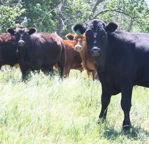
Cattle near Sanger, North Dakota, which lies above the Missouri River about 20 miles north of Mandan. They ran away when I approached.
Excavated livestock watering pond near Sanger, North Dakota.
Consider these to be artificial potholes. Here, the main problems are the concentration of alkali salts.
Before the 1960s, this was ranching country, with little else to support the economy. Now, there are jobs provided by the Minekota utilities corporation, which burns strip-mined coal for electric power.
Lone Wolf Saloon in Center, North Dakota,
It had three customers by early afternoon on Friday, July 16. I show this photo of the saloon where the coal miners hang out in lieu of a photo of the distant plants, which were too far to photograph well.
The plumes of the emissions stack run continuously, day and night. We also saw plumes west of Sanger, North Dakota, where something similar is taking place about ten miles to the northeast. Coal mining is another indicator that we had left the Upper Midwest for the true west. The Upper Midwest is underlain by the wrong kinds of rocks, and the glacial cover is much thicker.
From the coal-fired power plants, power lines head off toward Bismarck-Mandan. That city is literally lit up by strip-mining. It’s bright city lights also come with the consequence of carbon pollution. Concern about greenhouse emissions doesn’t seem to be a problem around here, probably because jobs are at stake. Another important point, is that these folks are used to taking whatever is thrown at them by the weather, blizzards, thunderstorms, hail, floods, droughts, locusts, deep freezes. It’s the city folk who seem to care most.
A side note on the issue of global warming. At 3:01 PM on July 16, 2009, we watched a local resident get out of his massive white Chevy pickup truck and walk into the gas station. In addition to the requisite blue jeans, he was wearing a puffy down coat over a thick insulated gray sweatshirt. I doubt that he is that concerned about global warming.
Curiously, there was a wind farm of several dozen turbines located between the two coal mining operations, probably within sight of both.
Immigration
Our side trip to Center was not taken to do genealogy, but simply to visit the place where Kristine’s grandparents met in Oliver County. The county seat in Center, North Dakota, is not too far off the center of North Dakota. Center's water tower was perched on the highest hill, a butte left over from countless rainstorms of the past, each of which removed a little of the landscape.
Water tower for Center, North Dakota.
This tank is one of the most photogenic we’ve seen. It will make a nice addition to our water tower album.
It’s a good thing the water is enclosed in a tank. Just below the tank was a puddle in the process of drying up in the steady wind.
Dried up puddle below the water tower in Center, North Dakota.
Its surface was fractured with mud-cracks in the brown, silty, pebble-free mud. They tend to curl upward because shrinking is greatest at the top, where the finest mud and clay settled.
After the water tower, we wandered around town. Kristine’s grandmother was a schoolteacher who left Indiana for the edge of the frontier. At the time, many schools were simple, one-room affairs like this one, which had been moved to the center of town by the Historical Society.
One-roomed prairie schoolhouse in Center, North Dakota.
In the county building, we met Mickie McNulty-Eide, Deputy Commissioner for Deeds, who helped us locate the ancestral homestead on Kristine’s side of the family.
Mickie McNulty-Eide, the Deputy Commissioner of Deeds for Oliver County.
Homesteads were 160 acres in size, which is the area of a quarter section of land. A section, which contains 640 acres, is a mile square. Each township has 36 sections. Doing the math, there would have been 144 homesteads per township,
Map from the land records for Oliver County, North Dakota featuring Section 10 of Township 142 East, Range 82 West.
This is the section of land homesteaded by Kristine’s great grandparents who emigrated from Denmark. Her great grandfather was named Christian Hoy Jensen. Her great grandmother's name had several versions among them Mette and Meta M. The family dropped the Jensen part of the surname, leaving Hoy as the last name for the descendants. The black squares show the buildings of the homestead, where Henry Victor Hoy, Kristine's grandfather, grew up and then, as a young man, ranched.
Using my Delorme Atlas and the odometer of the car, we drove dirt and gravel farm roads until we reached the quarter section of land homesteaded by her relatives.
Valley of Sherk Creek, with the land of Henry Victor Hoy in the background.
Their homestead lay in the base of a lovely valley cut by Sherk Creek, provided a southerly aspect for warmth, good water, a protected site for crops, good rangeland on the higher slopes, and easy road access. Prairie wildflowers were in full bloom, Black-eyed Susans, purple vetch, and wild rose.
Panel of prairie wildflowers above Sherk Creek, North Dakota on July 16, 2009.
They did not farm. They ranched. I find no sense of the Upper Midwest here. It’s pure west. In fact the North Dakota Cowboy Hall of Fame is only a few hours to the west.
Road to Medora
Having spent half the day in search of our family past, we took a beeline to Medora, where we had booked a room for the night. Our first stop was Sweet Briar Lake, just northeast of New Salem.
Sweet Briar Lake, near New Salem, North Dakota.
It was a typical reservoir. In map view, it was carrot-shaped, adorned with triangular points of drowned tributaries. I looked for the dam, but couldn’t find it. I suspect the road had been built right over it’s top. Also typical were steep banks eroded by waves.
Richardton, North Dakota, founded in 1883, was our next stop.
Entry sign for Richardton, North Dakota.
To the right was a historical marker, with the following text: “The Yellowstone Expedition of 1876 organized to quell the hostile Sioux, marked from Fort Abraham Lincoln May 17, 1876 and camped near Young Mans Butte about two miles east of this marker on May 23, 1876. Between Young Mans Butte and Richardton, the Custer Trail intersects the highway, continues in a general westerly direction, and enters Montana near Beach North Dakota. The trail extends to the banks of the Little Big Horn River in Montana where Custer and a Portion of the 7th Cavalry were annihilated by Hostile Indians on June 25, 1876.”
In nearby Taylor, we drove by the “Sit ‘n Bull Bar. Clearly, were still on the Custer Trail. The next event of significance was the first of several pumping oil wells.
Oil well and tanks 2-3 miles east of Belfield, North Dakota.
The water story here is about contamination. When fossil fuels are trapped beneath the earth, the sequence from top down is gas, oil, and briny water. This briny water, when it comes up with the oil under pressure, is one of the hardest management tasks of the oil business.
Our final stop was the Theodore Roosevelt National Park, probably one of the least visited in the nation. The story behind the park is fascinating. At one time, there were more than 40,000,000 buffalo grazing the high plains. By the time Teddy Roosevelt arrived in 1883, there were just a few thousand left. This was during the Gilded age, when shooting large game animals is just what men did for sport. So, Teddy took a train from New York to bag a buffalo before they were completely gone.
Though the hunting conditions were poor, he was successful in getting his trophy and sending the head back east on the train. But in the process, he had fallen in love with the west. It was here that this extraordinary man was converted to become the nation’s most conservation minded president.
Entry sign at the Painted Canyon Visitors Center, Medora, North Dakota.
Badlands of Painted Canyon, Theodore Roosevelt National Park, Medora, North Dakota.
There we met Patti Schaefer, who works for a foundation dedicated to sharing the park with tourists. What she liked about freshwater was that it clarifies when you let it settle. Brown water becomes clear when you let the mud settle out. She also likes fishing, especially for catfish, denizens of murky water. On the down side she was concerned about the recent fish kills in Patterson Lake, a reservoir above Dickenson. Even worse, she said, was the Red River, which residents outside of North Dakota usually refer to as the Red River of the North. It drains the northeastern part of the state toward Hudson Bay. Her concern was the pollution: “You can’t drink it, swim in it or even look at it. It’s disgusting.”
Things are greener around here, which is nice, but they are green because of the recent terrible winter, which is not so nice. Frequent storms made many roads, including Interstate 94, impassable.
The other attendant had a most unusual name, “Quadraline.” She said that my question about freshwater was one of the “weirdest” she had ever heard and “really ambiguous.” I explained that it was less ambiguous than it was open ended, designed to capture whatever was on someone’s mind, in order to compare results across the country. She likes water you can taste; otherwise “why drink it at all.” She hates the bottled stuff that isn’t flavored and “tastes like nothing.” Even worse is water that’s treated too much. Water from deep wells around here, she said, is very soft and it “makes awesome coffee and awesome tea. There’s no crud in it, you know,” referring to the “scum that forms on tea,” when you use hard water.
This was a Friday night during peak tourist season. We were lucky to get a room.


